Special Community Meeting Wed May 6th 6:00PM to 7:30PM
El Dorado Hills CSD Norm Rowett Pavilion 1021 Harvard Way, EDH, CA 95762
All El Dorado Hills residents are invited to participate!
The El Dorado Hills Area Planning Advisory Committee is hosting the El Dorado County Planning Department Long Range Planning open house for the El Dorado Hills Community Design Standards.
This is an opportunity for El Dorado Hills residents to participate and provide feedback for the EDH Community Design Standards project that will help define design standards for commercial, multi-family, and mixed-use projects in El Dorado Hills.
Please stop by and help EDH APAC and other El Dorado Hills residents provide input on what future El Dorado Hills Commercial, Multi-Family, and Mixed-Use Developments will look like.
El Dorado County Long Range Planning Staff Message:
Hold the Date!OnWednesday, May 6, 2026 at 6:00 PM, County staff, design consultants and members of the El Dorado Hills Area Planning Advisory Committee (APAC) will hold an open house to receive community feedback on the first (Administrative) Draft El Dorado Hills Design Standards and Guidelines (EDH DSG). For details and how to participate, please see the May 6, 2026, open house meeting flyer(PDF, 437KB).
El Dorado County Long Range Planning Department Is looking for El Dorado Hills residents to volunteer
From the County Long Range Planning Department Announcement
Help Shape the Future of El Dorado Hills!
El Dorado County’s Planning and Building Department is creating new community design standards for the El Dorado Hills Community Region, and we want your input!
If you live, work, own property, or do building or design work in El Dorado Hills, you’re invited to join our Stakeholder Advisory Team (SAT) — a group of community members working with County staff and consultants to help create these new standards. Click here for information about the El Dorado Hills SAT and how to apply!
As a reminder, to make sure you are considered, please submit yourSAT application as soon as possible as the application period will be closing soon.
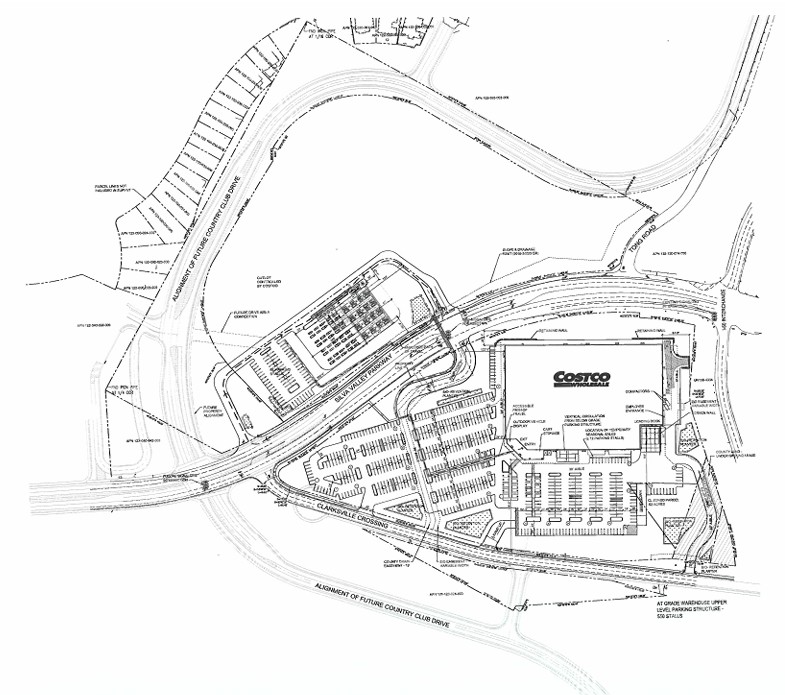
Notice: Availability of Draft Environmental Impact Report (DEIR) for the EDH Costco Project
The County of El Dorado has officially released the Draft Environmental Impact Report (DEIR) for the proposed El Dorado Hills Costco Project (Project No. PROJ21-0003). This release initiates a formal public review period under the California Environmental Quality Act (CEQA).
Project Overview
The proposed project involves the development of a Costco Wholesale warehouse and associated fueling station on an approximately 32-acre site within the El Dorado Hills Business Park. The site is located near the intersection of Silva Valley Parkway and Tong Road.
60-Day Public Review Period
The Draft EIR is now available for public review and comment. The review period spans 60 days, providing community members and agencies the opportunity to examine the environmental analysis and provide feedback.
Review Period Starts: January 21, 2026
Review Period Ends: March 23, 2026, at 5:00 PM
Public Information Meeting
The County will host an in-person meeting to provide information and answer general questions regarding the Draft EIR.
Date: Wednesday, February 25, 2026
Time: 6:00 PM – 8:00 PM
Location: Cameron Park Community Services District Community Center (Assembly Hall)
Address: 2502 Country Club Dr., Cameron Park, CA 95682
Guidelines for Public Comment
EDH APAC reminds community members that this phase of the process is specifically dedicated to the environmental impacts of the project as detailed in the Draft EIR. Effective comments typically focus on the adequacy of the environmental analysis, the significance of identified impacts (such as traffic, noise, or air quality), and the proposed mitigation measures.
Note on “Project Merits”: Public comments regarding the general merits of the project—such as whether you support or oppose the presence of a Costco in this location—are handled at a later stage. Once the Final EIR is released, a public hearing will be scheduled before the El Dorado County Planning Commission to consider the project’s entitlements and approvals. That hearing will be the appropriate time for testimony regarding the project’s overall desirability.
Accessing Documents
You can review the County’s official Notice of Availability (NOA) and the Draft EIR documents at the links below:
The County of El Dorado has officially issued a Notice of Preparation (NOP) for a Draft Environmental Impact Report (EIR) regarding the Gateway El Dorado Specific Plan (SP25-0001/GPA25-0001/Z25-0004). This notice marks the beginning of the formal environmental review process under the California Environmental Quality Act (CEQA).
As part of this process, the County will host a Public Scoping Meeting to receive community input.
Project Overview
The Gateway El Dorado Specific Plan proposes a mixed-use development on approximately 97.74 acres located within the El Dorado Hills Business Park.
Key project details include:
Location: South of Highway 50, primarily along Latrobe Road and White Rock Road.
Commercial Development: New commercial zoning along Latrobe Road for retail and service-oriented businesses (one- to four-story buildings).
Residential Development: Multifamily units with densities between 15 and 24 dwelling units per acre, totaling between 140 and 493 new units.
Research & Development: Maintenance of an R&D core for light manufacturing, offices, and laboratories.
Open Space: Approximately 24.34 acres dedicated to open space, primarily encompassing Carson Creek and its tributaries for habitat preservation.
Project Description
PROJECT LOCATION AND EXISTING USES: The proposed Gateway El Dorado (GED) Specific Plan project site consists of approximately 97.74 acres in El Dorado County, located within the El Dorado Hills Business Park approximately 1.3 miles south of U.S. Highway 50, west of Latrobe Road and north of Golden Foothill Parkway (Assessor’s Parcel Numbers (APNs) 117-210-019, -021, -023, -039, -044, -045, -048, -049, -050, -054, -059, -060, -061, -069, -070, and -071). The General Plan land use designation for the project site is Research & Development (R&D) and the site is zoned Research and Development–Design Review Community (R&D-DC).
PROPOSED PROJECT: The Gateway El Dorado Specific Plan proposes a mixed-use development spanning approximately 97.74 acres within the El Dorado Hills Business Park. The plan includes the retention of a Research & Development (R&D) core, where existing and future R&D buildings—ranging from one to four stories with a maximum floor area ratio (FAR) of 0.5 will be maintained for uses such as light manufacturing, offices, laboratories, and related activities. New commercial zoning along Latrobe Road will introduce one- to four-story commercial buildings with a maximum FAR of 0.5, providing space for retail and service-oriented businesses. Some commercial parcels are designated to buffer residential neighborhoods from the R&D core, with more intensive uses (such as auto-related services) limited to certain northern parcels.
Residential development will consist of multifamily units, with densities generally between 15 and 24 dwelling units per acre. These will be constructed as townhomes, apartments, or condominiums—typically in two- to four-story buildings organized with shared amenities and common areas. Select parcels are designated as Multifamily Residential/Commercial Flex (MFR/C), allowing these lots to be developed entirely as residential, commercial, or a mix of both, depending on market and project-specific factors. The plan provides for the construction of between 140 and 493 new dwelling units, and the development of between 563,220 and 723,956 square feet of non-residential building space, including existing structures.
The Environmental Impact Report (EIR)
The County, acting as the Lead Agency, will prepare an EIR to analyze the project’s potential impact on the environment. The study will evaluate several areas, including Aesthetics, Air Quality, Biological Resources, Cultural Resources, Greenhouse Gas Emissions, Hydrology, Noise, and Transportation.
Public Scoping Meeting Details
The purpose of the scoping meeting is to allow the public and agencies to provide input on the scope and content of the environmental information to be included in the EIR.
Date: Thursday January 29, 2026
Time: 6:00 PM
Location: El Dorado Hills Community Services District Norm Rowett Pavilion
Address: 1021 Harvard Way, El Dorado Hills, CA 95762
ProvidingPublic Comment
The community is encouraged to submit comments regarding the environmental review. Please note that at this stage of the process, comments should focus specifically on environmental concerns, questions about potential impacts, and observations regarding the scope of the study. Comments regarding the “merits” of the project (whether one likes or dislikes the project itself) are generally addressed later in the entitlement process. The current goal is to ensure the EIR is comprehensive and addresses all relevant environmental issues.
Deadline for Written Comments: February 10, 2026, by 5:00 PM.
Submit to: Bianca Dinkler, Planning Division (bianca.dinkler@edcgov.us)
Public review and comment period ENDS on August 19, 2025
From the June 20, 2025 Notice of Availability:
DOCUMENT AVAILABILITY AND REVIEW PERIOD: This DEIR is available for public and agency review for a 60-day period beginning June 20, 2025, and ending August 19, 2025. The purpose of this comment period is to consider the content of the DEIR and the potential environmental impacts that may result from project implementation. Comments pertaining to the environmental impact analysis, criteria and thresholds, mitigation measures and alternatives presented in the DEIR will be considered by the County during preparation of the Final EIR. The Final EIR will include copies of the comments received during the comment period and the County’s responses to comments pertaining to the environmental review and DEIR. A subsequent scheduled public hearing will be conducted on the project upon completion of the Final EIR when the County considers action on the project. The County must certify the Final EIR prior to project approval. If you wish to be notified of that hearing date, please provide your name and mailing address to the Planning and Building Department.
REDUCED IMPACT ALTERNATIVE: Preparation of an EIR requires the lead agency, in this case the County, to consult with local Native American Tribes (Tribes) that are traditionally and culturally affiliated with the project area regarding the presence of tribal cultural resources (TCRs). Through the consultation process with local Tribes, it was revealed that TCRs exist within the site and would be impacted by the project and could not be avoided. In addition, the Latrobe School District indicated during preparation of the DEIR that its existing schools could not absorb the increase in students generated by the project and requested a reduction in the number of conventional housing units. To address potential significant impacts, an EIR is required to evaluate an alternative that would avoid or lessen environmental impacts while still meeting most of the objectives of the project. In collaboration with the Tribes and Latrobe School District, a new land use plan, the Reduced Impact Alternative (RIA), was developed which avoids impacts to TCRs and reduces the total number of residential units from 918 to 763, including limiting the number of conventional housing units to a maximum of 150 with the remainder restricted to Active Adult. The RIA proposes a 7.5-acre Village Park with 1.6 acres of the park containing a Planned Development (PD) overlay designation that could allow for neighborhood commercial uses to serve the plan area, similar to the proposed project. These potential commercial uses would require approval of a separate Conditional Use Permit and Planned Development. There would be two additional Neighborhood Parks, 4.4 and 2.2 acres in size, for a total of 14.1 acres in parks and 44.4 acres in open space. Given the ability to address significant impacts to TCRs and the concerns of the Latrobe School District, it was decided that the RIA should be analyzed at a project-specific level so that the County could ultimately approve the RIA instead of the proposed project.
This DEIR therefore evaluates the land use plan that was originally submitted by the applicant as the proposed project and also analyzes the RIA at the project-specific level, either of which could be approved by the County. Based on analysis completed at this time, County staff intends to recommend the RIA for approval because it avoids impacts to TCRs, reduces additional environmental impacts, and is the land use plan preferred by both the Tribes and the Latrobe School District.
June 2025 Creekside Village Specific Plan Draft Environment Impact Report Documents
The Draft Environmental Impact Report is available in ten sections – beginning with section 0.1 Creekside Village SP Cover Page, through section 6.0 Creekside Village SP DEIR Preparers. The applicant then provides all ten sections in one document, the Combined DEIR Creekside Village Specific Plan. This is further supported by ten appendices beginning with appendix A – Creekside Village SP DEIR Appendix A – NOP and Combined Comments, and concluding withe appendix J – Creekside Village SP DEIR Appendix J – Fire Safe Plan.
EDH Fire Station 85 – 1050 Wilson Blvd, EDH CA 95762
The El Dorado County Planning Department has posted a revised Notice of Preparation for a DRAFT Environmental Impact Report for the proposed EDH Costco project. The EDH 52 commercial/retail component of the past project proposals has been withdrawn. The Project had an original Scoping Meeting the was held virtually on September 8, 2020.
Due to the project seeking to keep existing the existing land zoning (Commercial Regional – or Big Box development) the project will complete the Draft Environmental Impact Report, and the Final Environmental Impact Report, and the seek project entitlements and approval at a future Planning Commission hearing. The Planning Commission will review grant approval or denial of the project entitlements. Any appeal of the Planning Commission decision (approval or denial) would be considered by the Board of Supervisors.
Notice of Preparation for a DRAFT Environmental Impact Report and Revised Scoping Meeting (March 10 2025)
The El Dorado County Planning Division, Discretionary Planning Unit, is releasing the attached revised Notice of Preparation (NOP) for a draft Environmental Impact Report (DEIR) for the El Dorado Hills Costco project (project) (File Nos. PD15-0001, CUP23-0012, V22-0001) located in unincorporated El Dorado County (County). The DEIR is being prepared in accordance with the California Environmental Quality Act (CEQA) (Public Resources Code [PRC] Sections 2100 et seq. and the CEQA Guidelines (14 California Code of Regulations [CCR] Sections 1500 et seq). The project and location are briefly described below.
PROJECT DESCRIPTION: Planned Development Permit (PD15-0001) for a Costco Wholesale Member Warehouse retail store and Costco Wholesale fuel facility; Conditional Use Permit (CUP23-0012) for a tire center, outdoor vehicle display, and recurring outdoor Christmas Tree sales; Variance (V22-0001) to allow building-attached signage square footage area beyond the current allowance in the El Dorado County Zoning Ordinance. The property, identified by Assessor’s Parcel Numbers 122-720-002, -003, -018, -019, -020, and -021, consists of 43.26 acres, of which 13.79 acres are to remain undeveloped, and is located adjacent to the north of the U.S. Highway 50 and bisected by Silva Valley Parkway, in the El Dorado Hills area, Supervisorial District 1.
PROVIDING COMMENTS:
El Dorado County is soliciting written comments from public agencies, organizations, tribes, and individuals regarding the scope and content of the environmental document. Because of time limits mandated by State law, comments should be provided at the earliest possible date, but no later than 5:00 p.m. on, March 31, 2025. Please send written comments to: El Dorado County Development Services Department-Planning Services, Attention: Cameron Welch, 2850 Fairlane Court, Placerville, CA 95667 or via email: EDHCostco@edcgov.us.
SCOPING MEETING:
The County of El Dorado will hold a scoping meeting to receive comments regarding the scope and content of the environmental document and answer general questions regarding the environmental process. The meeting will be on March 10, 2025 from 6:00 p.m. to 8:00 p.m. at the El Dorado Hills Fire Station, Station 85, located at 1050 Wilson Boulevard, El Dorado Hills, CA 95762.
Staff-led informational workshop presented for the public and Planning Commissioners
El Dorado County Planning Department to offer a Staff led informational workshop for the the public and Planning Commissioners to learn about the proposed Village of Marble Valley Specific Plan and the Lime Rock Valley Specific Plan. The Public review period for the Draft Environmental Impact Reports for BOTH projects closed in July 2024. Both projects are expected to be scheduled for formal hearings before the Planning Commission, and then the Board of Supervisors within the next several months, with the intent to have the projects reviewed for environmental impacts, entitlements, and approvals finalized by the end of 2024.
PURPOSE The purpose of this informational workshop includes, but is not limited to, the following:
Provide the Planning Commission and public a general overview and introduction of both the proposed Village of Marble Valley Specific Plan (VMVSP) and the proposed Lime Rock Valley Specific Plan (LRVSP) projects, including the size and scope.
Give a “heads-up” that these projects are in the pipeline and will soon be formally brought before the Planning Commission for consideration and recommendation to the Board of Supervisors.
Provide an opportunity for decision-makers and the general public to ask questions share comments prior to a formal hearing.
Encourage staff to pursue additional research regarding questions from Planning Commissioners and the general public, so that the future formal hearing may be better informed and responsive to specific questions. The intention of this staff-led informational workshop is that it be a non-binding introduction to the projects for the Planning Commission in a setting less formal than a public hearing. No action nor recommendation to the Board of Supervisors is being sought from Planning Commissioners for this item at the August 8, 2024, Planning Commission Meeting. County CEQA Consultant, Pat Angell from Ascent Environmental will deliver most of the introductory presentation. Guest speakers from County Divisions and Local Agencies may deliver brief relevant information. The proportion of Applicant participation in delivering this introduction is expected to be proportional to other projects heard by the Planning Commission.
County Transportation Department Director Martinez shares letter concerning Carson Crossing Drive area issues with EDH APAC.
El Dorado County Director of Transportation Rafael Martinez provided EDH APAC a copy of a letter to El Dorado Hills residents addressing concerns about traffic and development issues near Carson Crossing Drive.
In his letter Director Martinez identified six areas that the Transportation Department is exploring, based on concerns expressed by El Dorado Hills residents.
Analyzing Speed Surveys, Setting Speed Limits, and Stop Signs
Enhanced Signage and Road Markings
Pedestrian Crosswalks and Signals
Traffic Enforcement
Community Engagement and Education
Implementation of Roundabouts
Director Martinez addresses the difficulty of restricting truck traffic on Carson Crossing Drive due to ongoing construction projects in the area (both in the adjacent El Dorado Hills Business Park, and the ongoing construction of the residential Lennar Heritage developments).
EDH APAC appreciates the ongoing dialog of the Transportation Department with El Dorado Hills residents. Since El Dorado Hills is the largest community in the County, and is the source of the majority of new development, residents frequently forget that the Transportation Department has obligations that extend to all areas of the County, and many of those other County Communities lack development funding to provide road capacity improvements, and like El Dorado Hills, the funding required for ongoing road maintenance. EDH APAC welcomes community participations as we address transportation and circulation issues in our Communities.
45 day public review period to end on September 9, 2024
The El Dorado Count Planning and Building Department released the Notice of Availability for the Town and Country Village El Dorado DRAFT environmental impact report on July 26, 2024. A 45 day public review period has been established to accept public comments, questions, and concerns, regarding the ENVIRONMENTAL impacts of the project. Public review comments can be submitted via email to TownAndCountryElDorado@edcgov.us.
This DEIR identifies that the proposed project could result in significant environmental impacts to the following CEQA topics: Aesthetics; Air Quality, Greenhouse Gas Emissions, and Energy; Biological Resources; Cultural Resources; Geology and Soils; Hazards and Hazardous Materials; Hydrology and Water Quality; Noise; Transportation; Tribal Cultural Resources; and Wildfire.
In the Notice of Availability, the County also details that they will conduct a meeting to receive comments regarding the content of the DEIR and answer general questions regarding the environmental process. The meeting will be held in-person with a remote option via Zoom on Thursday, August 22, 2024, from 5:30pm to 7:30pm at the El Dorado County Planning and Building Department, 2850 Fairlane Ct, Building C, Placerville, CA 95667 in the Planning Commission hearing room. The Zoom meeting link is accessible at the following: https://us06web.zoom.us/j/88543474078 – This is NOT a Planning Commission Hearing, but a presentation for the public facilitated by El Dorado County.
The project site is located in El Dorado County, California, approximately 500 feet north of U.S. Highway 50, east of Bass Lake Road. The approximately 60.5-acre site is identified by Assessor’s Parcel Numbers (APN) 119-080-12, -021 and -023. The project site is located in the southern central portion of the Bass Lake Hills Specific Plan (BLHSP); the northern portion of the project site is located within the Community Region of the El Dorado County General Plan, and the southern portion of the site is located within the Rural Region.
The project site includes two areas: the Project Development Area and the Program Study Area. The Project Development Area consists of the northernmost and southernmost 30.3 acres of the project site, and would be developed with two hotels, retail services, two restaurants, a museum, an event center, associated parking, 56 residential cottages for employee housing, and an additional 56 residential cottages that may be rented on a daily or extended stay basis. The Program Study Area consists of the central and easternmost 30.2 acres of the project site, and may include future development of additional hotels, medical facilities, senior housing, townhomes and cottages, and other uses allowed by the proposed zoning districts. Development within the Program Study Area of the project site is not currently proposed; however, a maximum buildout scenario is included for program level analysis in the EIR. Vehicle access to the project site would be provided by private roads connecting to Bass Lake Road to the west and to Country Club Drive to the north. In addition to on-site utility improvements, full buildout of the proposed project would require installation of off-site water, sewer, and natural gas utilities within Bass Lake Road, other nearby roads, and with respect to the sewer line, generally to the west along Old Bass Lake Road/Lincoln Highway towards Carson Creek.
The proposed project would require approval of: A General Plan Amendment BLHSP Amendment BLHSP Public Facilities Financing Plan Amendment Rezone Planned Development Tentative Subdivision Map Conditional Use Permit (CUP) Other responsible agency approvals (e.g., El Dorado LAFCO related to annexation of the project site into EID’s service area).
The Officers of the El Dorado Hills Area Planning Advisory Committee (EDH APAC) submitted a letter expressing concerns about the tentative review schedule of multiple projects impacting El Dorado Hills in the third and fourth quarters of 2024.
Adequate time for thoughtful project review and analysis along with input from residents results in projects that offer increased benefits for a community to better balance against potential negative impacts.
The El Dorado County Planning and Building Department must operate in a manner that adheres to both state law, as well as El Dorado County policies and ordinances, in a process that respects the rights of project applicants, and County residents. EDH APAC recognizes that Planning and Building Staff have a challenging task to respond to both developers and the community. EDH APAC is grateful for the collaborative manner that County Staff conducts project review, and the amount of assistance that Staff generously provides to EDH APAC volunteers, and the community.
Please note that the letter contains a typo regarding the date of the Town & Country Village El Dorado Scoping meeting date – the letter indicates August 2024, when in fact the Scoping meeting was held in August 2023.

 Loading...