Staff-led informational workshop presented for the public and Planning Commissioners
El Dorado County Planning Department to offer a Staff led informational workshop for the the public and Planning Commissioners to learn about the proposed Village of Marble Valley Specific Plan and the Lime Rock Valley Specific Plan. The Public review period for the Draft Environmental Impact Reports for BOTH projects closed in July 2024. Both projects are expected to be scheduled for formal hearings before the Planning Commission, and then the Board of Supervisors within the next several months, with the intent to have the projects reviewed for environmental impacts, entitlements, and approvals finalized by the end of 2024.
PURPOSE The purpose of this informational workshop includes, but is not limited to, the following:
Provide the Planning Commission and public a general overview and introduction of both the proposed Village of Marble Valley Specific Plan (VMVSP) and the proposed Lime Rock Valley Specific Plan (LRVSP) projects, including the size and scope.
Give a “heads-up” that these projects are in the pipeline and will soon be formally brought before the Planning Commission for consideration and recommendation to the Board of Supervisors.
Provide an opportunity for decision-makers and the general public to ask questions share comments prior to a formal hearing.
Encourage staff to pursue additional research regarding questions from Planning Commissioners and the general public, so that the future formal hearing may be better informed and responsive to specific questions. The intention of this staff-led informational workshop is that it be a non-binding introduction to the projects for the Planning Commission in a setting less formal than a public hearing. No action nor recommendation to the Board of Supervisors is being sought from Planning Commissioners for this item at the August 8, 2024, Planning Commission Meeting. County CEQA Consultant, Pat Angell from Ascent Environmental will deliver most of the introductory presentation. Guest speakers from County Divisions and Local Agencies may deliver brief relevant information. The proportion of Applicant participation in delivering this introduction is expected to be proportional to other projects heard by the Planning Commission.
The Officers of the El Dorado Hills Area Planning Advisory Committee (EDH APAC) submitted a letter expressing concerns about the tentative review schedule of multiple projects impacting El Dorado Hills in the third and fourth quarters of 2024.
Adequate time for thoughtful project review and analysis along with input from residents results in projects that offer increased benefits for a community to better balance against potential negative impacts.
The El Dorado County Planning and Building Department must operate in a manner that adheres to both state law, as well as El Dorado County policies and ordinances, in a process that respects the rights of project applicants, and County residents. EDH APAC recognizes that Planning and Building Staff have a challenging task to respond to both developers and the community. EDH APAC is grateful for the collaborative manner that County Staff conducts project review, and the amount of assistance that Staff generously provides to EDH APAC volunteers, and the community.
Please note that the letter contains a typo regarding the date of the Town & Country Village El Dorado Scoping meeting date – the letter indicates August 2024, when in fact the Scoping meeting was held in August 2023.
County issues NOA 107 days following scoping meeting
45 day public comment period closes on August 12, 2024
From the notice of availability –
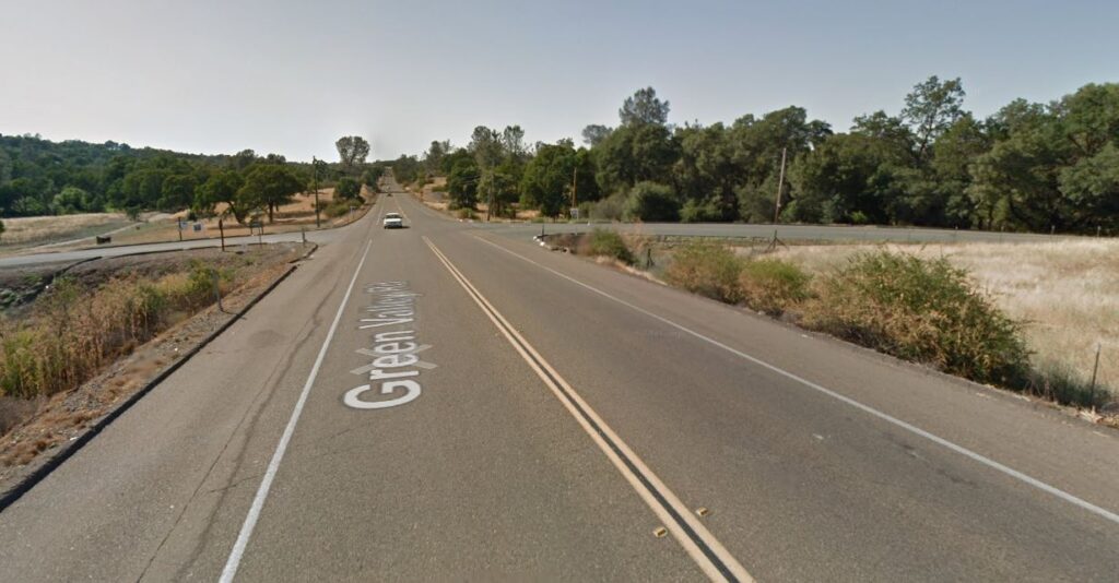
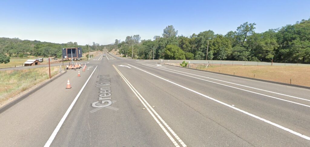
PROJECT DESCRIPTION: The proposed project is a request to amend the General Plan land use designations of the project site from Low Density Residential (LDR) and Open Space (OS), to High Density Residential (HDR), LDR, and Public Facilities (PF); a Rezone from Residential Estate, Ten-Acre (RE-10), Residential Estate, Five Acre- (RE-5), and Recreational Facilities, Low Intensity (RF-L), to Residential, Single-Unit (R1), RE-5, OS, and Recreational Facilities, High Intensity (RF-H); and a Tentative Subdivision Map to subdivide the project site into 379 residential lots, a clubhouse lot, a park site, 13 landscape lots, and nine (9) open space lots. 214 of the proposed lots would be age-restricted for residents 55 years or older. 18 of the Residential Estate (RE) zoned lots would be located generally along the northern, eastern, and southern perimeter of the site, as well as along Green Valley Road. The project includes two proposed access roadway connections to Green Valley Road (C-Drive and A-Drive). The project site is within the General Plan designated El Dorado Hills Community Region boundary. The project would require the El Dorado Local Agency Formation Commission (LAFCO) to approve annexations of the site into the service boundaries of El Dorado Hills Fire Department for fire protection services, El Dorado Hills Community Services District (CSD) for parks, recreation, and other community services, and the El Dorado Irrigation District (EID) for water and wastewater services. Additionally, the proposed project would include improvements to Green Valley Road, as well as other off-site improvements for transportation, water supply, wastewater conveyance, and utilities.
PROJECT LOCATION: The project site is located in an unincorporated area of El Dorado County, in the eastern portion of the El Dorado Hills Community Region. The project site encompasses 280.70-acres and is located on five parcels identified by Assessor’s Parcel Numbers (APNs) 126-020-001, 126-020-002, 126-020-003, 126-020-004, and 126-150-023. The majority of the site is located south of Green Valley Road, with the exception of the northern tip of the site that is north of Green Valley Road (portion of APN 126-150-023). This portion is being removed from the project as part of a Boundary Line Adjustment that is being processed under a separate application to the County.
Providing Public Comments related to ENVIRONMENTAL IMPACTS
Providing Comments: The DEIR is available for public and agency review for a 45-day period beginning June 27, 2024, and ending August 12, 2024. The purpose of this comment period is to consider the content of the DEIR and potential environmental impacts that may result from project implementation, not the positive or negative attributes of the proposed project itself. Comments pertaining to the environmental impact analysis, criteria and thresholds, mitigation measures and alternatives presented in the DEIR will be considered by the County during preparation of the Final EIR. The Final EIR will include copies of the comments and the County’s responses to comments pertaining to the environmental review and DEIR.
Informational Meeting: El Dorado County will hold a meeting to receive comments regarding the content of the DEIR and answer general questions regarding the environmental process. The meeting will be held in-person with a remote option via Zoom on Thursday, July 11, 2024, from 5:30pm to 7:30pm at the El Dorado County Planning and Building Department, 2850 Fairlane Ct, Building C, Placerville, CA 95667 in the Planning Commission hearing room. Here is the Zoom link: https://us06web.zoom.us/j/83691325117
Planning Commissioners to get CEQA refresher in June 27th Workshop
The El Dorado County Planning Commission, facing an aggressive project review schedule for the second half of 2024, will begin with a public workshop on the California Environmental Quality Act (CEQA) at this Thursday’s Planning Commission Hearing.
CEQA – long cited by development proponents and opponents alike as the reason for California’s prohibitively expensive and often litigated project approvals process – has been in place since 1970, signed into law by California Governor Ronald Reagan.
Subsequent governors and California agencies, such as City councils, County Boards of Supervisors, and more, have complained that the CEQA process is why development in California is so expensive – and why their pet projects don’t come to fruition. Truthfully, CEQA’s intent was to allow for a full public review of potential significant environmental impacts from development projects. It allows for both project applicants, and community residents, to weigh in on Environmental concerns. CEQA allows for “significant unavoidable environmental impacts” if they provide a public benefit.
The Planning Commission’s tentative project review schedule in the second half of 2024
The Planning Commission has provided to EDH APAC a tentative review schedule from their 2024 calendar. It is rather aggressive:
June 27 CEQA training for Planning Commissioners – Planning Commissioners have asked that the workshop be made available to the public.
July 11Generations At Green Valley EIR presentation. 379 single-family residential lots, 1 Park lot, 1 clubhouse, 9 open space lots, 13 landscape lots, and 3 road lots on Green Valley Road in El Dorado Hills. Public Scoping Meeting was held on March 12, 2024
July 25Town and Country Village El Dorado EIR presentation Two hotels, two restaurants, a museum, an event center, associated parking, 56 residential cottages for employee housing, and an additional 56 residential cottages that may be rented on a daily or extended stay basis. Public Scoping Meeting was held in August 2024
August 8 Village of Marble Valley Specific Plan and Lime Rock Valley Specific Plan informational. Marble Valley SP – 2,342 acres of land consisting of approximately 3,236 dwelling units and 475,000 square feet of commercial. The project is located in between El Dorado Hills and Cameron Park area south of Highway 50. Public Scoping Meeting was held in March 2013 Lime Rock Valley SP – Lime Rock Valley Specific Plan proposes for the development of 740 acres of land consisting of approximately 800 dwelling units. The project is located south of Highway 50 in the Cameron Park area. Public Scoping Meeting was held in March 2013
Planning Commission June 27th CEQA Workshop Presentation Materials
BOS Receives Staff Presentation at January 9, 2024 Meeting.
At the January 9, 2024 Board of Supervisors Meeting, the Department of Transportation provided a El Dorado Countywide Housing and Employment Projections, 2018 – 2045 Memorandum and Presentation pertaining to the 2024 Major Update of the Traffic Impact Fee (TIF) Program, recommending that the Board adopt an annual residential growth rate of 0.62% and an annual employment growth rate of 0.62% through 2045.
The annual residential and employment growth rates impacts the TIF formula, that helps to set the fee schedule for development fees for impacts to the El Dorado County Road Network.
This is the first time that a more detailed set of historical data for both residential growth, and employment growth has guided the analysis for the determination of the County-wide growth rate(s) – the data is based on Community Regions (El Dorado Hills, Cameron Park, Shingle Springs Diamond Springs/El Dorado, and Placerville Community Regions), and also incorporates Rural regions as “Balance of West Slope”. Key data points for Residential Growth indicated the following actual growth rates:
El Dorado Hills 3.30% Cameron Park 0.44% Shingle Springs 1.06% Diamond Springs 0.23% Placerville 0.10% Balance of West Slope 0.62%
A PDF version of the Staff Presentation is located at the end of this article.
Community Region Growth Residential ACTUAL vs Projected
Jobs to Housing Ratio
The Board of Supervisors voted 4 to 1 to approve the adopting of the updated residential and employment growth rates
DISCUSSION / BACKGROUND
This is the second workshop to discuss policy items, specifically data and information focused on growth rates and projections, related to the 2024 Major Update to the Traffic Impact Fee (TIF) Program.
On December 8, 2020 (Item 39, Legistar 20-1585), the Board of Supervisors adopted the 2020 Major Update to the TIF Program. That update made a number of changes to the program, including adjusting the Countywide residential growth rate from 1.03% to 0.70% annually; setting the anticipated level of grant funding to 10%; reducing the non-residential equivalent dwelling unit (EDU) shift from 65% to 62%; consolidating the TIF Zones across the unincorporated West Slope from 8 Zones to 3 Zones; prorating fees for residential single-family dwellings based upon square footage, as required by California Assembly Bill (AB) 602; adding Vehicle Miles Traveled as a traffic impact measure under the California Environmental Quality Act (CEQA), as required by California Senate Bill (SB) 743; upholding the use of reduced fees for age-restricted housing; and upholding the offset for affordable housing as outlined in Board Policy B-14.
The 2024 Major Update to the TIF Program will consider the projected growth throughout the County through the year 2045; allocate the growth to community regions, including updates to those regions based upon the 2020 US Census; and update the County’s Travel Demand Model (TDM) to reflect the projected growth patterns. The Board will also be asked to consider the grant funding and non-residential offsets, based upon anticipated funding opportunities and the effects of residential growth upon commercial development. Utilizing the updated TDM, a deficiency analysis will be performed to establish a nexus with any needed capital improvements resulting from the projected growth, which will be included in the Capital Improvement Program (CIP), and the anticipated improvement costs will be distributed across the number of permits anticipated to be issued over the next twenty years to update the TIF Program Fee Schedule.
The workshop, held on December 5, 2023, launched the 2024 Major Update with the analysis of growth projections across the Western Slope of El Dorado County (West Slope) through 2045. The El Dorado County Housing and Employment Projections, 2018 – 2045 Memorandum (Memorandum) has been prepared by the County’s consultant, BAE Urban Economics, Inc. (BAE) (Attachment A).
Following the December 5th workshop, Transportation staff and their consultants collected historical data and information requested by the Supervisors for presentation and discussion at this workshop.
Base Year Housing and Employment Estimates
At this time, the extended growth projections utilize the same 2018 base year housing and employment estimates as those used in the growth projections used in the 2020 Major Update, which cover only the West Slope of the County. Growth within the Lake Tahoe Basin is under the jurisdiction of the Tahoe Regional Planning Agency (TRPA). BAE considered five sources of estimates for housing trends and four sources of estimates for jobs trends in the West Slope. For purposes of the analysis, BAE has chosen to use the 2019 County estimates compiled by Kimley-Horn & Associates (KHA) that are based on the County’s Geographic Information System (GIS) mapping data, as they are the most current, localized estimates available.
KHA is currently developing updated baseline estimates of existing West Slope housing units and employment. BAE will incorporate the updated baseline estimates into a refined set of West Slope housing unit and employment growth projections, using the annual growth rates to be adopted by the Board as a result of this item. Community Region growth allocations will also be included at separate, subsequent Planning Commission and Board of Supervisor meetings in early 2024. While the starting point for the projections will move up from 2018 to 2023, the average annual rates of housing unit and employment growth are not expected to change significantly.
Residential (Housing) Growth Rates
As shown in the Population/Housing Units/Households section of Table 1 in Attachment A, four of five projections studied yielded average annual growth rates for the period ranging between 0.53 and 0.73 percent. The fifth source (California Department of Finance Projections to 2045) yielded a negative average annual growth rate and is an anomaly within the data sources; as such, this outlier was not considered in estimating the County’s average annual residential growth rate. The current average annual residential growth rate adopted by the Board in 2020 is 0.70%.
Employment Growth Rates
In the Employment section of Table 1 in Attachment A, the 2018 to 2045 employment growth rates for three of the four sources range between 0.45 and 0.84 percent per year. The fourth source (2010 to 2023 Caltrans Growth Trended to 2045) is an anomaly and yielded an average annual growth rate more than twice the next highest employment growth rate; this outlier was not considered in estimating the County’s likely employment growth rate. The current average annual employment growth rate adopted by the Board in 2020 is 0.67%.
Housing Unit Projections
The Housing section of Table 2 in Attachment A shows housing unit projections for the West Slope from 2018 to 2045 based on the growth rates identified in Table 1. For planning purposes, BAE suggests that the County consider a growth projection that reflects the average of the residential projections, excluding the Department of Finance projection mentioned previously, shown in the Housing section of Table 2 in Attachment A. This would yield 9,996 new residential units for a total of 64,917 residential units in the West Slope area by 2045, yielding a 0.62% annual average residential growth rate. This is slightly higher than the County’s 2010 to 2018 growth estimates and the Sacramento Area Council of Governments (SACOG) 2040 projections, but less drastic than the growth rates suggested by the Department of Finance (DOF) and Caltrans.
Employment Projections
The Employment section of Table 2 in Attachment A shows a series of employment projections for the 2018 to 2045 period, drawing the potential employment growth rates from the Employment section of Table 1 in Attachment A and applying them to the County’s estimated 2018 West Slope base year jobs estimate. As with the residential growth projections, BAE suggests that the County use an average of the projections shown in the Jobs section of Table 2 for the purposes of projecting West Slope job growth for the 2018 to 2045 period, excluding the Caltrans Trended Growth projection. This yields an average annual employment growth rate of 0.62%, with 6,776 new jobs and a 2045 job total of 44,095.
Summary
Based on the data and methodology described above, BAE and Transportation recommend the County use the West Slope housing unit and employment growth assumptions outlined on page 4 of Attachment A for planning purposes:
The figures in the table on page 4 of Attachment A provide the County with growth assumptions that fall within the middle range of the growth projections available from various sources and data available for this study. Further, the recommended housing unit and employment growth rates suggest the County would be producing new housing at a rate that will correspond with the rate of new employment growth, meaning that the growth pattern would be balanced and the County’s jobs/housing balance would not deteriorate over time.
Assumption of too high of a growth rate could lead to unnecessary capital improvements and an overabundance of road capacity that surpasses county need, while too low of a growth rate would collect insufficient funds over time to cover the construction of projects required as a result of growth.
Next Steps
Based on input from the Board and direction from County staff, BAE will make any necessary refinements and finalize the West Slope growth projections. Then, BAE will analyze the pattern of growth within the West Slope and allocate the 2018 to 2045 housing unit and employment growth among Community Regions and the balance of the West Slope area. BAE will then review and discuss the refined projections and growth allocations with the Planning Commission and the Board to solicit input before finalizing the projections for the County’s planning purposes.
Staff is recommending that the Board adopt an annual residential growth rate of 0.62% and an annual employment growth rate of 0.62% for the period 2018 to 2045, and direct staff and BAE to commence allocation of the projected growth for presentation to the Planning Commission and Board of Supervisors.
ALTERNATIVES
The Board could choose a different annual growth projection within the ranges reflected in the analysis presented, or continue with the current annual rates of 0.70% for residential growth and 0.67% for non-residential growth. Staff and their consultants would need to search for documentation to support a growth projection that is not included in Attachment A.
PRIOR BOARD ACTION
On December 8, 2020 (Item 39, Legistar 20-1585), the Board adopted the 2020 Major Update to the TIF Program.
On December 5, 2023 (Item 37, Legistar 23-2051), the Board received a presentation on the 2024 Major Update to the TIF Program, including data regarding growth projection options.
OTHER DEPARTMENT / AGENCY INVOLVEMENT
Planning and Building Department, Long Range Planning Unit
CAO RECOMMENDATION / COMMENTS
Approve as recommended.
FINANCIAL IMPACT
There is no change to Net County Cost associated with this agenda item as the Major Update and associated administrative costs are covered by TIF collected and are included in the CIP budget for FY23/24 and FY24/25. The adopted growth rates will affect the number of assumed projects developed over the next twenty years throughout the West Slope of the County and could potentially result in an increase/decrease to the traffic impact fees charged for both residential and non-residential building permits.
CLERK OF THE BOARD FOLLOW UP ACTIONS
N/A
STRATEGIC PLAN COMPONENT
The TIF Program is a major funding source for the CIP, which is a vital part of the Infrastructure component of the County Strategic Plan. Adequate infrastructure is necessary for the Economic Development component and is a requirement of the County General Plan. Safe roads are a crucial factor in the Public Safety component of the County Strategic Plan.
Development would be equally split between Sacramento County and El Dorado Hills
AKT Development and UC Davis Health submitted a proposal to both El Dorado County and the City of Folsom on Friday December 22, 2023 for a project described as a “Community for Health and Independence” that would provide a residential development for healthy senior communities, and residential housing for disabled residents. The project proposes 4000 residential housing units in Sacramento County, and 4000 residential housing units in El Dorado Hills. Parks, Schools, and commercial development would also occur in both counties – with El Dorado Hills initially planned for one Elementary/Middle School site, which would appear to be inside the boundaries of the tiny Latrobe Union School District.
The project would also feature A 200-acre UC Davis teaching, research and health complex planned as the centerpiece of the community.
The Project seeks annexation into the city of Folsom for parcels south of the Folsom City limit in Sacramento County along the Sacramento and El Dorado County lines south of White Rock Road and the future Empire Ranch Rd US50 interchange. Parcels for the in El Dorado Hills are primarily located west and south of the EDH Business Park, and the Four Seasons and Heritage residential villages. The project would also construct a roadway system that would extend from the future Empire Ranch Rd extension to White Rock Road in Sacramento County, and provide a connector road/beltway from White Rock Rd in Sacramento County south and east to Latrobe Road in El Dorado County
In El Dorado Hills, the County zoning designations for the majority of the parcels and adjacent parcels are:
AG-40 – Agricultutral Grazing (40 acre minimum)
IL – Industrial Light
RL-80 – Rural Lands (80 acre minimum)
RL-40 – Rural Lands (40 acre minimum)
PA-40 – Planned Agricultural (40 acre minimum)
LA-40 – Limited Agricultural (40 acre minimum)
RE-10 – Residential Estate (10 acre minimum)
EDC Parcel Zoning in East Plan Area
Project documents have not yet been posted on the El Dorado County Planning Department website, or the County ETRAKiT website.
Conceptual Annexation Proposal On December 22, 2023, the City of Folsom received a conceptual annexation and development proposal from AKT and UC Davis for their “Community for Healthy Living and Independence” project. The proposed project includes land in both Sacramento and El Dorado counties. The western portion of the project, located adjacent to Folsom in unincorporated Sacramento County, includes 1,416 acres and the proposed development of 4,511 housing units along with commercial, office, and medical research uses. City staff will review the proposal and present their analysis and findings to the City Council for discussion and further direction in the next two to three months.
The proposed development area is located south of White Rock Road and adjacent to the Sacramento County border with El Dorado County. Any proposed annexation that involves a change to the City’s boundaries is subject to the review and approval of Sacramento County’s Local Agency Formation Commission (LAFCo) in addition to approval by the Folsom City Council.
The details on the City of Folsom website further goes on to describe the tentative schedule:
It is anticipated that the review of the proposal will take approximately 2 to 3 months. At the conclusion of staff analysis, an item will be brought forward to the City Council for consideration and direction to staff. A more detailed schedule will be provided in the near future.
Residential Densities
The residential housing densities proposed in the concept document vary from Low Density residential single family homes to High Density Multifamily.
Commercial, Business, Retail
The Project narrative submitted to the City of Folsom includes descriptions of development areas for work, business, and shopping.
Village Mixed Use | Mixed-use (MU)designated sites include retail, office, services (0.5 FAR), and residential uses (9-30du/ac)
Commercial + Research | The Plan includes General Commercial (GC) and Regional Commercial (RC) areas for neighborhood retail and a Lifestyle Center, as well as Industrial/Office Park (IND/OP) areas intended for Research and Development.
UC Davis Site/Complex | The Plan includes a large complex for UC Davis (IND/OP) that is proposed to serve as a center for the study of aging and longevity.
Schools | Elementary schools and a middle school (PQP) are sited within neighborhoods and will provide an employment opportunity within the community.
Civic Safety| Law enforcement and fire protection services are planned in the MU Village area
Transportation Plan in El Dorado County
The project envisions a new connector road from White Rock Road in Sacramento County that is identified as “Village Parkway” that would roughly travel north to south through the project area. In El Dorado County a connector road from “Village Parkway” identified as “Latrobe Connector” would cross over from Sacramento County to El Dorado County in a west to east direction providing a connection to Latrobe Road south of the EDH Business Park and the Heritage and Blackstone Villages. Another connector road, further to the south, would extend from Village Parkway eastward into El Dorado County, and is identified as “Rural Parkway”.
Plan Areas
Since the project spans across municipalities in two counties, the Sacramento County side of the project is referred to as the “West Plan Area” in the Project Narrative document, and the El Dorado County side of the project is referred to as the “East Plan Area”.
East Plan Area Land Use
The residential land use in El Dorado County proposes:
295 Single Family units over 105 acres
2157 Single Family High Density units over 490 acres
337 Multi-Family Low Density units over 46 acres
232 Multi-Family Medium Density units over 19 acres
311 Multi-Family High Density units over 19 acres
The Age-Target Residential land use proposes
526 Age Targeted Single Family High Density units over 119 acres
144 Age Targeted Multi-Family Low Density units over 20 acres
160 Age Targeted Multi-Family High Density units over 10 acres
Mixed Use land use proposes
144 Mixed Use Village residential units over 32 acres
Commercial, Employment and Civic land use proposes
10 acres of General Commercial use
100 acres of industrial/Office Park UC Davis Health Complex
15 acres of Industrial/Office Park Research
10 acres for public or quasi public Schools
Timeline
This project envisions 8000 housing units over 4000 acres in two counties. The applicants seek an annexation of the property in Sacramento County to the City of Folsom, requiring approval of Sacramento County LAFCO.
It would also require extensive analysis in El Dorado County for a General Plan Amendment, parcel rezones, and likely a Specific Plan, and Planned Development entitlement. The complexity is frankly very ambitious, and is expected to take several years to review and process.
As official project documents are made public in El Dorado County, EDH APAC will post and link them on a documents page for the project on the EDH APAC website.
Project Narrative Document posted to City of Folsom website
Two scoping meetings scheduled for August 8, and 9, 2023
El Dorado County has issued a Notice of Preparation of a Draft Environmental Impact Report for the proposed Town and Country Village El Dorado development project. The project site is located north of Highway 50 east of Bass Lake Road and south of Country Club Drive.
The Project Development Area consists of the northernmost and southernmost 30.3 acres of the project site, and would be developed with two hotels, retail services, two restaurants, a museum, an event center, associated parking, 56 residential cottages for employee housing, and an additional 56 residential cottages that may be rented on a daily or extended stay basis, which may require a conditional use permit.
A second project site of the development is “the Program Study Area” – this site consists of the central and easternmost 30.2 acres of the project site, and may include further development in the future such as additional hotels, medical facilities, senior housing, townhomes and cottages, and other uses allowed by the proposed zoning districts.
The project seeks the following entitlements:
General Plan Amendment
The General Plan Land Use Designation for the project site is Adopted Plan (AP). The General Plan designates the portion of the project site north of Country Club Drive as within the El Dorado Hills Community Region, and the area south of Country Club Drive as within the Rural Region. The proposed General Plan Amendment would modify the Community Region boundary to include the entire project site within the El Dorado Hills Community Region
Bass Lake Hills Specific Plan Amendment
The existing BLHSP land use designations for the project site are L.7-PD and L.2-PD. The BLHSP designates the portion of the project site north of Country Club Drive as L.7-PD [maximum allowable density of 0.7 dwelling units per acre (du/ac)], and the portion south of Country Club Drive is designated L.2-PD (maximum allowable density of 0.2 du/ac). The requested BLHSP Amendment would establish three new land use designations for the specific plan: Commercial (C), Multi-Family Residential (MFR), and Open Space (OS). Application of these proposed new land use designations would be limited the project site. These land use designations would be allocated to the project site as follows: 26.2 acres of C, 23.0 acres of MFR, and 7.6 acres of OS. In addition to changing the land use designations of the project site, the BLHSP Amendment would include content revisions to the BLHSP itself to accommodate the proposed project. As part of the BLHSP Amendment, a Fiscal Impact Analysis and update to the Bass Lake Hills Specific Plan Public Facilities Financing Plan (PFFP) would be completed. The PFFP sets forth a strategy to finance the backbone infrastructure and other public facilities required to serve the proposed land uses in the BLHSP.
Rezone
The current zoning designation for the entire project site is RE-10. The proposed project would require the approval of a Rezone from RE-10 to the following El Dorado County zoning districts: Community Commercial (CC), Multi-Unit Residential (RM), and Open Space (OS). Additionally, as required by the BLHSP, the Planned Development Combining District (-PD) suffix would be added to all the zoning district designations listed above.
Buildout of the Project Development Area of the project site would include two 150-room hotels, 112 residential cottages, retail uses, restaurants, an event center/museum, recreational amenities, and parking lots (see Figure 3).
Additionally, the Project Development Area would be developed with internal roadways and a new Class I Bicycle Path. Development within the Program Study Area of the project site is not currently proposed to occur concurrently with development of the Project Development Area; however, a maximum buildout scenario is included for program level analysis in the EIR.
Two Scoping Meeting dates:
Two scoping meetings – both open to agencies, organizations, and individuals – will be held to receive public comments and suggestions on the scope of environmental issues to be studied in the EIR. The scoping meetings will be held as follows:
In-PersonTue Aug 8, 2023 6PM An in-person scoping meeting will be held: Date: Tuesday, August 8, 2023 Time: 6:00 PM Location: El Dorado Hills Fire Department Community Room 1050 Wilson Boulevard El Dorado Hills, CA 95762
Virtual Wed Aug 9, 2023 11AM A virtual scoping meeting will be held: Date: Wednesday, August 9, 2023 Time: 11:00 AM Link: https://us06web.zoom.us/j/86521211649 Call In Phone #’s: 530-621-7603 or 530-621-7610 Webinar ID: 865 2121 1649
EDH APAC encourages residents to attend one or both of the planned Scoping Meetings to provide comments, questions, and concerns. Comments will be addressed as required by law in the California Environmental Quality Act (CEQA) and included in the Final Environmental Impact Report.
Project Applicants provide responses to EDH APAC comment letter submitted for February 16, 2023 TAC Meeting
The applicants for Project Frontier, a proposed distribution and sortation facility consisting of two buildings totaling four million square feet, to be located at the southern end of the El Dorado Hills Business Park on the west side of Latrobe Road between Royal Oaks Drive on the north, and Wetsel-Oviatt Road to the south, have supplied a response letter to the comments submitted by EDH APAC to the El Dorado County Technical Advisory Committee Meeting held on February 13, 2023. The response letter indicates that the project’s application for a Conditional Use Permit (CUP) to allow one of the project’s buildings to exceed current El Dorado County height limits, has been provided a determination by the County Planning Department that the appropriate decision making authority rests with the Zoning Administrator (Director of Building and Planning).
From the response letter:
The project applicant has applied for a conditional use permit to allow one of the buildings to exceed current height limits. A conditional use permit is a discretionary approval and the El Dorado County Zoning Code (“Zoning Code”) requires a noticed public meeting for a conditional use permit. Section 130.52.021 provides for the Zoning Administrator or Planning Commission to be the review authority for a conditional use permit, and “[t]he determination of the review authority shall be made by the Director based on the nature of the application, and the policy issues raised by the project.”
A conditional use permit is not required to allow the project uses. The Matrix of Allowed Uses in Table 130.23.020 of the County Zoning Code provides that “Wholesale Storage and Distribution,” the same use as the proposed project, is an allowed use in the Research and Development Zone. A local agency cannot selectively or arbitrarily require a discretionary approval for uses that the Zoning Code allows by right with a ministerial building permit approval.
The applicant understands that, because the proposed project uses are consistent with zoning, are allowed by right, and have been previously analyzed in numerous environmental analyses, the Planning Department has determined that the Zoning Administrator is the appropriate decision-making body for the conditional use permit that is limited to the proposed building height.
The full response letter addressing the items raised by EDH APAC is embedded here:
March 14, 2023 Applicant Responses to EDH APAC Feb 16, 2023 TAC Meeting Comments Letter
EDC Auditor Controller March 14, 2023 letter to EDH APAC
El Dorado County Auditor Controller Joe Harn provided the following letter to EDH APAC addressing Sales Tax and Apportionment questions raised by EDH APAC.
Auditor Controller Harn’s letter is embedded here:
Project Frontier Applicant Presentation at the EDH APAC March 15, 2023 6:30PM meeting
The project applicants will provide a project presentation and discussion at the Wednesday March 15, 2023 6:30PM EDH APAC Meeting. The meeting will be hybrid: in-person at EDH Fire Station 85 1050 Wilson Blvd, with virtual discussion via ZOOM, and streamed live on the EDH APAC YouTube Channel. The Room capacity does not exceed 100 guests. Meeting details and streaming links can be found on our March 13th meeting event page
EDH APAC Project Documents page updated with Draft Traffic Impact Analysis Report and all available project documents.
Green Valley Rd – Deer Valley Rd intersection 2012 prior to 2014 intersection improvements- looking westGreen Valley Rd – Deer Valley Rd intersection 2021 following 2014 intersection improvements – looking west
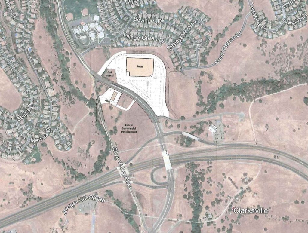
Following several ‘Stakeholder’ meeting sessions with representatives of the property owner, and Costco, El Dorado County has released the following Fact Sheet regarding a proposed Costco location in El Dorado Hills.
The location selected by Costco is on the east side of Silva Valley Parkway, north of the Highway 50/Silva Valley Pkwy interchange- just north of Tong Road, and south of Oak Meadow Elementary School, and the proposed alignment of the future extension of Country Club Drive. The project is expected to be developed in conjunction with, and as a component of the proposed EDH 52 project. This property is already zoned for Commercial Regional (CR) and by rights, is zoned for big-box commercial development, which makes a proposed Costco facility a compatible land use for the zoning. In terms of mitigating traffic impacts, Commercial Regional is best suited along major highway interchanges, removing traffic impacts from interior roadways.
Costco representatives revealed that an El Dorado County location is desired to help relieve the current over impacted Folsom location. They shared that there are other California Costco locations within 3 miles of each other, as the current Folsom and proposed El Dorado Hills locations will be. As a membership store, Costco has direct knowledge of where their members are located – from the identified target area in El Dorado County around El Dorado Hills, excluding the existing Folsom Costco members, there are currently 40,000 Costco Members, so the customer base already exists.
Costco seeks to be near highway interchanges for their stores, and many locations in El Dorado County have been evaluated for a site. Out of all highway interchanges in El Dorado County, only Silva Valley Parkway has the necessary capacity for the addition of a Costco Facility, as it currently measures a Level of Service (LOS) A. It already has the necessary road and highway capacity to meet this use. Questions were asked about other El Dorado County locations, but representatives indicated that El Dorado Hills Blvd/Latrobe Road at HWY50, to Town Center West, or to the Business Park, is currently at too poor a LOS level (C, D, and E, depending upon the time of day), and with the existing and planned developments in the area are physically too constrained to add more capacity. Other County locations, including interchanges such as Missouri Flat Rd, are also too limited by poor LOS levels, and the inability to add additional capacity, as existing development prevents adding more road space. Interchanges such as Cambridge Road, Cameron Park Dr, and Ponderosa Rd also lack the capacity for additional traffic volume, and are facing challenges in terms of costs just to increase capacity to meet existing needs. The Cameron Park Dr at HWY 50 interchange, as an example, is facing a $70 million dollar improvement to meet current needs, and isn’t projected to be completed for 10 years, if funding can be found. Even with these proposed improvements, the interchange would still fall short of required capacity to adequately mitigate the impacts of a project of the scope of the proposed Costco Project. Since Silva Valley Pkwy is currently an A-Rated interchange, Coscto would be mitigating impacts from their project, and would not need to fund a complete overhaul of a highway interchange, which would be prohibitively costly.
Costco representatives indicated in the Stakeholder meetings that in the El Dorado Hills customer target area of their study, there are approximately 40,000 current Costco members. The El Dorado Hills location is supported by their internally defined demographic metrics – over 40,000 residents in El Dorado Hills, nearly 15,000 in Cameron Park, upwards of 5,000 in Shingle Springs, 2,500 in Rescue, and 11,000 new homes planned in the Folsom Ranch development south of HWY50 (over 20,000 new residents in the next 20-25 years) on the future White Rock Rd Capitol Southeast Connector, which will terminate at the Silva Valley Pkwy/HWY 50 interchange. Locations further east in El Dorado County, such as Placerville, with only 10,000 residents, lack the population to provide an adequate customer base to support developing a new Costco store location.
The next steps in the proposed project will be the President of Costco visiting the El Dorado Hills site later in March/early April. If the President of Costco makes the determination that the site fits their defined needs, along with the market demographics, they could decide as early as April 2019 to proceed with the project. If they do, it is expected to take 18 – 24 months to gain environmental approvals and permitting, along with a full Environmental Impact Report and the resultant traffic study. If the project gains these approvals, it is estimated that it would take another 12 months to begin and complete construction. As the approvals process and construction timeline would take at best a minimum of three years, the earliest possible opening date would be in 2022.
If the project proceeds, El Dorado Hills Area Planning Advisory Committee members will be studying the project over the next several years, evaluating the Draft Environmental Impact Report when it is released, and making recommendations on the project, and any proposed mitigation. Representatives from Costco have already proposed keeping close communication with EDH APAC, and have agreed to conduct public outreach via EDH APAC and other community agencies and organizations, to educate residents on their progress, and to get community feedback, to help improve the project. Costco representatives have indicated their willingness to present their project at EDH APAC meetings during the approvals process, and to foster and maintain an open dialog as the project proceeds.


 Loading...