County Transportation Department Director Martinez shares letter concerning Carson Crossing Drive area issues with EDH APAC.
El Dorado County Director of Transportation Rafael Martinez provided EDH APAC a copy of a letter to El Dorado Hills residents addressing concerns about traffic and development issues near Carson Crossing Drive.
In his letter Director Martinez identified six areas that the Transportation Department is exploring, based on concerns expressed by El Dorado Hills residents.
Analyzing Speed Surveys, Setting Speed Limits, and Stop Signs
Enhanced Signage and Road Markings
Pedestrian Crosswalks and Signals
Traffic Enforcement
Community Engagement and Education
Implementation of Roundabouts
Director Martinez addresses the difficulty of restricting truck traffic on Carson Crossing Drive due to ongoing construction projects in the area (both in the adjacent El Dorado Hills Business Park, and the ongoing construction of the residential Lennar Heritage developments).
EDH APAC appreciates the ongoing dialog of the Transportation Department with El Dorado Hills residents. Since El Dorado Hills is the largest community in the County, and is the source of the majority of new development, residents frequently forget that the Transportation Department has obligations that extend to all areas of the County, and many of those other County Communities lack development funding to provide road capacity improvements, and like El Dorado Hills, the funding required for ongoing road maintenance. EDH APAC welcomes community participations as we address transportation and circulation issues in our Communities.
Development would be equally split between Sacramento County and El Dorado Hills
AKT Development and UC Davis Health submitted a proposal to both El Dorado County and the City of Folsom on Friday December 22, 2023 for a project described as a “Community for Health and Independence” that would provide a residential development for healthy senior communities, and residential housing for disabled residents. The project proposes 4000 residential housing units in Sacramento County, and 4000 residential housing units in El Dorado Hills. Parks, Schools, and commercial development would also occur in both counties – with El Dorado Hills initially planned for one Elementary/Middle School site, which would appear to be inside the boundaries of the tiny Latrobe Union School District.
The project would also feature A 200-acre UC Davis teaching, research and health complex planned as the centerpiece of the community.
The Project seeks annexation into the city of Folsom for parcels south of the Folsom City limit in Sacramento County along the Sacramento and El Dorado County lines south of White Rock Road and the future Empire Ranch Rd US50 interchange. Parcels for the in El Dorado Hills are primarily located west and south of the EDH Business Park, and the Four Seasons and Heritage residential villages. The project would also construct a roadway system that would extend from the future Empire Ranch Rd extension to White Rock Road in Sacramento County, and provide a connector road/beltway from White Rock Rd in Sacramento County south and east to Latrobe Road in El Dorado County
In El Dorado Hills, the County zoning designations for the majority of the parcels and adjacent parcels are:
AG-40 – Agricultutral Grazing (40 acre minimum)
IL – Industrial Light
RL-80 – Rural Lands (80 acre minimum)
RL-40 – Rural Lands (40 acre minimum)
PA-40 – Planned Agricultural (40 acre minimum)
LA-40 – Limited Agricultural (40 acre minimum)
RE-10 – Residential Estate (10 acre minimum)
EDC Parcel Zoning in East Plan Area
Project documents have not yet been posted on the El Dorado County Planning Department website, or the County ETRAKiT website.
Conceptual Annexation Proposal On December 22, 2023, the City of Folsom received a conceptual annexation and development proposal from AKT and UC Davis for their “Community for Healthy Living and Independence” project. The proposed project includes land in both Sacramento and El Dorado counties. The western portion of the project, located adjacent to Folsom in unincorporated Sacramento County, includes 1,416 acres and the proposed development of 4,511 housing units along with commercial, office, and medical research uses. City staff will review the proposal and present their analysis and findings to the City Council for discussion and further direction in the next two to three months.
The proposed development area is located south of White Rock Road and adjacent to the Sacramento County border with El Dorado County. Any proposed annexation that involves a change to the City’s boundaries is subject to the review and approval of Sacramento County’s Local Agency Formation Commission (LAFCo) in addition to approval by the Folsom City Council.
The details on the City of Folsom website further goes on to describe the tentative schedule:
It is anticipated that the review of the proposal will take approximately 2 to 3 months. At the conclusion of staff analysis, an item will be brought forward to the City Council for consideration and direction to staff. A more detailed schedule will be provided in the near future.
Residential Densities
The residential housing densities proposed in the concept document vary from Low Density residential single family homes to High Density Multifamily.
Commercial, Business, Retail
The Project narrative submitted to the City of Folsom includes descriptions of development areas for work, business, and shopping.
Village Mixed Use | Mixed-use (MU)designated sites include retail, office, services (0.5 FAR), and residential uses (9-30du/ac)
Commercial + Research | The Plan includes General Commercial (GC) and Regional Commercial (RC) areas for neighborhood retail and a Lifestyle Center, as well as Industrial/Office Park (IND/OP) areas intended for Research and Development.
UC Davis Site/Complex | The Plan includes a large complex for UC Davis (IND/OP) that is proposed to serve as a center for the study of aging and longevity.
Schools | Elementary schools and a middle school (PQP) are sited within neighborhoods and will provide an employment opportunity within the community.
Civic Safety| Law enforcement and fire protection services are planned in the MU Village area
Transportation Plan in El Dorado County
The project envisions a new connector road from White Rock Road in Sacramento County that is identified as “Village Parkway” that would roughly travel north to south through the project area. In El Dorado County a connector road from “Village Parkway” identified as “Latrobe Connector” would cross over from Sacramento County to El Dorado County in a west to east direction providing a connection to Latrobe Road south of the EDH Business Park and the Heritage and Blackstone Villages. Another connector road, further to the south, would extend from Village Parkway eastward into El Dorado County, and is identified as “Rural Parkway”.
Plan Areas
Since the project spans across municipalities in two counties, the Sacramento County side of the project is referred to as the “West Plan Area” in the Project Narrative document, and the El Dorado County side of the project is referred to as the “East Plan Area”.
East Plan Area Land Use
The residential land use in El Dorado County proposes:
295 Single Family units over 105 acres
2157 Single Family High Density units over 490 acres
337 Multi-Family Low Density units over 46 acres
232 Multi-Family Medium Density units over 19 acres
311 Multi-Family High Density units over 19 acres
The Age-Target Residential land use proposes
526 Age Targeted Single Family High Density units over 119 acres
144 Age Targeted Multi-Family Low Density units over 20 acres
160 Age Targeted Multi-Family High Density units over 10 acres
Mixed Use land use proposes
144 Mixed Use Village residential units over 32 acres
Commercial, Employment and Civic land use proposes
10 acres of General Commercial use
100 acres of industrial/Office Park UC Davis Health Complex
15 acres of Industrial/Office Park Research
10 acres for public or quasi public Schools
Timeline
This project envisions 8000 housing units over 4000 acres in two counties. The applicants seek an annexation of the property in Sacramento County to the City of Folsom, requiring approval of Sacramento County LAFCO.
It would also require extensive analysis in El Dorado County for a General Plan Amendment, parcel rezones, and likely a Specific Plan, and Planned Development entitlement. The complexity is frankly very ambitious, and is expected to take several years to review and process.
As official project documents are made public in El Dorado County, EDH APAC will post and link them on a documents page for the project on the EDH APAC website.
Project Narrative Document posted to City of Folsom website
The County of El Dorado Planning Commission will hold a public hearing on March 25, 2021 at 8:30AM to consider:
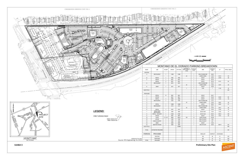
Rezone Z15-0002/Tentative Parcel Map P15-0006/Planned Development PD15-0004/ Conditional Use Permit S17-0015/Montano De El Dorado Phase I and II Master Plan submitted by MONTANO VENTURE 2, LLC to: 1) Rezone (Z15-0002) from Regional Commercial – Community Design Review Combining Zone (CR-DC) to Regional Commercial – Planned Development Combining Zone (CR-PD); 2) Commercial Tentative Parcel Map (P15-0006) on Assessor’s Parcel No. 118-010-012 to create a total of 12 commercial parcels from an existing 16.85-acre parcel, ranging from 0.72 acres to 3.48 acres in size, as part of proposed Phase II of the Montano De El Dorado Master Plan; 3) Planned Development (PD15-0004) to establish a Development Plan for the existing Montano De El Dorado Phase 1 development and the proposed Phase II expansion. Phase I consists of an existing commercial center, consisting of five buildings, on the 20.1-acre project site with a combined total of 39,645 square feet of floor area. Existing uses include retail stores, restaurants, and a bank. The proposed Phase II expansion consists of nine additional commercial buildings with a combined total of approximately 80,000 square feet of retail, restaurant, commercial and office uses, a 55,136 square foot, 100-room hotel, a small community pavilion and on-site parking, lighting, signage and landscaping; and 4) Conditional Use Permit (S17-0015) to allow outdoor special events and office uses within existing Phase I and proposed Phase II of the Montano De El Dorado Master Plan. The properties, identified by Assessor’s Parcel Numbers 118-010-012, 118-010-014, 118-010-015, and 118-010-016, consisting of 20.1 acres, is located approximately 0.5 mile south of U.S. Highway 50 on the east side of Latrobe Road at the intersection with White Rock Road, in the El Dorado Hills area, Supervisorial District 2. (County Planner: Tom Purciel, 530-621-5903) [An Environmental Impact Report (EIR) (State Clearinghouse No. 2017072027) consisting of a Draft EIR and Final EIR has been prepared for the project]
County Staff Reports and the project Final Environmental Impact Report (FEIR) as referenced in the Public Notice, have not yet been made available on the County’s Legistar website, or on the County’s eTRAKiT website. Project Documents are typically available about two weeks prior to a public hearing.
Any written correspondence should be directed to the County of El Dorado Planning and Building Department, 2850 Fairlane Court, Placerville, CA 95667 or via e-mail: planning@edcgov.us.
To ensure delivery to the Commission prior to the hearing, written information from the public is encouraged to be submitted by Thursday the week prior to the meeting. Planning Services cannot guarantee that any FAX or mail received the day of the Commission meeting will be delivered to the Commission prior to any action.
The County of El Dorado Board of Supervisors will hold a public hearing in the Supervisors Meeting Room, 330 Fair Lane, Placerville, CA 95667 on February 23, 2021, at 1:00 p.m., to consider Pre-Application PA20-0002/Carson Creek Village Specific Plan Conceptual Review submitted by ANDREA MATARAZZO/PIONEER LAW GROUP for an Initiation Hearing (Conceptual Review) of a proposed Specific Plan that would allow medium- and high density attached and detached residential development with a potential build-out of 600 to 800 dwelling units, approximately 110,000 square feet of new commercial floor area, approximately 8.5 acres for a park and paseo site, and approximately 26.5 acres of open space. The property consisting of 98 acres, is located within the central portion of the existing El Dorado Hills Business Park, along the west side of Latrobe Road, north of the intersection with Golden Foothill Parkway
El Dorado County provides Notice of Public Hearing.
The County of El Dorado Board of Supervisors will hold a public hearing in the Supervisors Meeting Room, 330 Fair Lane, Placerville, CA 95667 on October 20, 2020 at 11:00 a.m., to consider: 1) the adoption of a Resolution to partially decertify the Final Environmental Impact Report (FEIR) for the General Plan Biological Resources Policy Update (Project) only as it relates to the County’s determination that focusing on preservation of oak woodland habitat in the Highway 50 corridor was not the best course of action and it was not feasible to focus on preserving the oak woodlands within the Highway 50 corridor; 2) directing staff to augment the administrative record as authorized by CEQA, including the missing reports and studies, as set forth in the court’s ruling in Rural Communities United v. County of El Dorado, Superior Court of the County of El Dorado, Case No. PC20170536; and 3) the adoption of a Resolution to recertify the portions of the FEIR that were decertified by the adoption of the prior resolution. The proposed action is in response to the Court’s orders in the writ issued in the above noted litigation. The FEIR for the Project was certified by adoption of Resolution 127-2017 on October 24, 2017. The proposed decertification is a partial decertification; all other parts of the FEIR/EIR will remain in effect.
Two new hearings added to previously announced November and December Hearings
The El Dorado Hills APAC has been notified by the County of El Dorado Planning Department of two new hearings to be scheduled regarding the Central El Dorado Hills Specific Plan project for the proposed Serrano Westside (Old Executive Golf Course) and the Pedregal (west of El Dorado Hills Blvd at Wilson Way) planning areas. The new third and fourth hearings will be scheduled for January 2020. The first January 2020 Planning Commission Hearing will be held IN El Dorado Hills, in the evening, allowing the opportunity for more El Dorado Hills residents to contribute to the process.
From the the Planning Department update:
During today’s agenda review meeting with Planning Commission Chair Gary Miller, Dave Livingston, and Tiffany Schmid, the following Planning Commission hearing schedule was determined for the Central El Dorado Hills Specific Plan project. This will allow several opportunities for public testimony and also comply with the Board’s direction on November 5th to hold a Special Meeting in January 2020 in El Dorado Hills during the evening.
**Public Testimony will be taken at the November, December and January (Special Meeting) hearings and then closed for Planning Commission deliberation and action at the final hearing in January/February 2020. Hearing #1 – November 14, 2019 Regular Planning Commission Meeting (Building C Hearing Room)(meeting to be continued to December 12, 2019)
Hearing #2 – December 12, 2019 Regular Planning Commission Meeting (Building C Hearing Room) (meeting to be continued to Special Meeting in January 2020 in El Dorado Hills-evening)
Hearing #3 – January 2020 Special Planning Commission Evening Meeting – El Dorado Hills (TBD)(meeting to be continued to Regular Meeting in January/February 2020)
Wednesday November 13th 7PM EDH APAC Meeting -Serrano Associates Presentation
The El Dorado Hills APAC Wednesday November 13th 7PM meeting be focused on an overview and recent changes to the proposed Central El Dorado Hills Specific Plan in a presentation by representatives of Serrano Associates.
This is an opportunity for El Dorado Hills residents to learn about the proposed project, and a question and answer session will follow the presentation. Keep in mind – El Dorado Hills APAC has no land use authority, and only provides resident feedback on proposed development projects to the Applicant, the County Planning Department, the Planning Commission, and to the Board of Supervisors. We will be conducting a respectful discussion with the project applicant, who is under no obligation to appear at our EDH APAC meeting. We appreciate the applicant’s effort in providing a review and discussion of their proposed project.
The EDH APAC page for CEDHSP documents and details can be found HERE
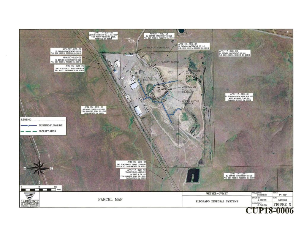
Nine new supporting documents have been added to the eTRAKiT file for the proposed Conditional Use Permit for El Dorado Disposal to operate a temporary debris and green waste processing facility.
The property, identified by Assessor’s Parcel Numbers 117-020-08 and 117-020-09, consists of 97 acres, and is located on the end of Wetsel/Oviatt Road approximately 1.4 miles west of the intersection with Latrobe Road, in the El Dorado Hills area. This will function as a temporary sorting location for the existing Material Recovery Facility (MRF) on Throwita Way in Placeville/Diamond Springs while the existing MRF is reconfigured and soil contamination is corrected over a proposed three year period.
The Throwita Way MRF will continue to be used for serving the public. Materials from the MRF will be transported by El Dorado Disposal vehicles to the Wetsel/Oviatt Road temporary facility for sorting. From there the sorted materials will enter the existing El Dorado Disposal waste streams. There will be no public access at the Wetsel/Oviatt Road temporary facility, and no access from other commercial or municipal waste handlers.
The EDHAPAC CUP18-0006 Project Document(s) Page isHERE From the October 4, 2018 Proposed Mitigated Negative Declaration and Initial Study_Staff Report Exhibit H (CUP18-0006) *(Page 33/44) –
Ditches and berms exist on‐site that direct some run‐on stormwater around the site and into an existing stormwater basin. Minor grading and culvert installation would occur to create drainage swales to route all stormwater run‐on around the facility and stormwater runoff into a proposed stormwater basin. Minor grading would also occur to construct a level pad for the C&D sorting line. Overall, temporary site construction activity would consist of minor grading to construct a level pad and drainage swales, excavating a stormwater detention basin, construction of a temporary concrete pad, installation of temporary trailer/office, portable toilets, and temporary power, and paving portions of the site. Construction activity is expected to last 20 working days. The temporary site would require approximately 700 cy of soil fill and 3,000 cy of soil cut. The excess soil quantities would be stockpiled on‐site. Construction of the temporary site is expected to take approximately 20 workdays.
Temporary Off‐site Facility—Trip Generation C&D debris and green/wood waste delivered to the MRF by the public would be transferred to this site. The temporary site would utilize existing access provided by Wetsel‐Oviatt Road. No paving or other improvements to this road are planned. Franchise greenwaste truckloads (route trucks) and separated C&D debris commercial truckloads would be diverted from the MRF and delivered directly to the site. Based on information provided by the Draft Joint Technical Document Containing Facility Plan for C&D Recycling Operations Plan for Green/Wood Waste Processing by Lawrence & Associates (Appendix I), it is anticipated that the temporary site would incur an average of 55 daily two‐way traffic trips. Of these, approximately 49 trips are trips diverted from the existing site to the temporary site. Of these diverted trips, approximately 29 trips would consist of greenwaste and C&D waste truck trips and the remaining 20 trips would consist of employee and visitor trips. The remaining 6 two‐way trips would be new and consist of maintenance and fueling truck trips and water truck trips. The greenwaste and C&D waste truck trips consist of set routes to the MRF facility. As a result of the diversion of the truck trips to the temporary site, some greenwaste and C&D waste truck trip routes would result in a reduction in total vehicle miles traveled (VMT), while other trip routes would result in an increase in total VMT. Based on information provided by the applicant, the net increase of total VMT for the diverted truck trips would result in an additional 1,504 miles per year. The new maintenance and fueling truck trip lengths are based on the Draft Joint Technical Document Containing Facility Plan for C&D Recycling Operations Plan for Green/Wood Waste Processing by Lawrence & Associates (Appendix I). The total trip lengths for employees and visitors are based on the CalEEMod default trip lengths for general industrial projects.
1.5 ‐ Required Discretionary Approvals The proposed project would require the following discretionary approvals: Conditional Use Permit Update (Existing Site)—El Dorado County Conditional Use Permit (Temporary Site)—El Dorado County Extension of sewer facilities—El Dorado Irrigation District Right‐of‐Way Abandonment—El Dorado County Department of Transportation
As previously indicated, the MRF operates under an existing special use permit. Because this project is primarily a renovation of existing operations, the existing special use permit would be revised via an updated Conditional Use Permit. As part of the revision, the total allowable daily tonnage would no longer be split up into waste types, but instead simplified to 700 tpd maximum. This maximum tpd is consistent with the existing permit, but allows for more flexibility in the amount of each waste type received. Actual waste processed at the site is not expected to change as a result of the renovation or update to the Special Use Permit.
El Dorado County has announced the recently updated the Zoning Ordinance (Title 130 of the County Ordinance Code) with minor amendments. Most of the changes were correcting minor formatting errors and typos to ensure internal consistency between the Articles contained within the Zoning Ordinance. The amendment also included 11 parcel specific rezones to several properties which were identified as having a documented mapping error.
In addition to formatting corrections, outdoor entertainment uses are now allowed with the approval of a Conditional Use Permit in the Commercial Main Street (CM) zone; personal service uses are allowed either by right or with the granting of a Conditional Use Permit in the Professional Office (CPO) zone; and winery production is allowed with the granting of a Conditional Use Permit in the Commercial Main Street (CM) zone.
The adopted ordinance is posted on the County website at: https://www.edcgov.us/Government/longrangeplanning/Pages/2017-Zoning-Ordinance-Updates.aspx
A review of project documents available on El Dorado County’s TRAKiT online project/permit tracking system indicates eleven projects with updated documents and or event dates for review or public hearings.
Temporary Information Trailer to answer questions regarding the units and amenities within a new senior living facility while it is being built at 2020 Town Center West Way, El Dorado Hills
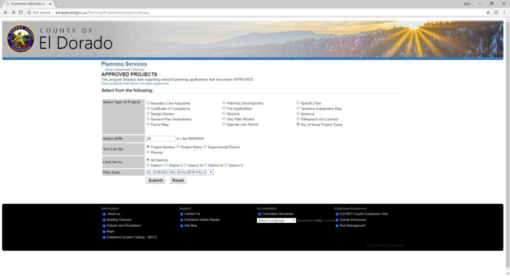
El Dorado County has switched away from the legacy Project Status pages ( here and here ) for tracking project documents (not on the Legistar Calendar, for agency actions), to a new online permit tracking website. The old Project Status search pages would allow a user to select a specific area: El Dorado Hills, Cameron Park, Rescue, etc -or a Supervisor District. It would also allow users to search for specific types of documents: Design Review, General Plan Amendment, Parcel Map, Rezone – or even ALL documents types
Then it would generate a search result listing of all projects that matched:
The new site eTrackiT has been difficult to navigate, as users cannot just select an area, and type of project files they want to search for, as they previously did on the legacy Project Status pages. A user looking for project information almost has to know one of the following:
Project Name: This has to exactly match the project name that the County enters into the system – the more commonly known public marketing name may not generate a result
Description: Must match what County staff have entered into the tracking system
Developer Name: Must match what Staff have entered into the tracking system. Developers frequently use different legal names, for different projects
Project Number: Users must know the project number to find the project – these are not commonly found by the public. The County has also modified project numbering to accommodate the new system
APN Number: Users must know the Assessor’s parcel number for the project
It is possible to generate a search result list, if the user enters the beginning of a document number – such as PD (planned development), TM (tentative subdivision map) , Z (zoning), etc. But this will generate results from all areas of the County.
EDH APAC has recently added nine new project details to project document pages for El Dorado Hills area projects found in eTRAKiT. These are:


 Loading...