Skip to content Skip to main navigation Skip to footer

Commercial

Town and Country Village El Dorado NOP DEIR and Scoping Meetings

Two scoping meetings scheduled for August 8, and 9, 2023

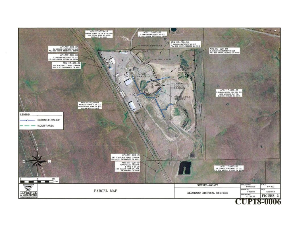
El Dorado County has issued a Notice of Preparation of a Draft Environmental Impact Report for the proposed Town and Country Village El Dorado development project. The project site is located north of Highway 50 east of Bass Lake Road and south of Country Club Drive.

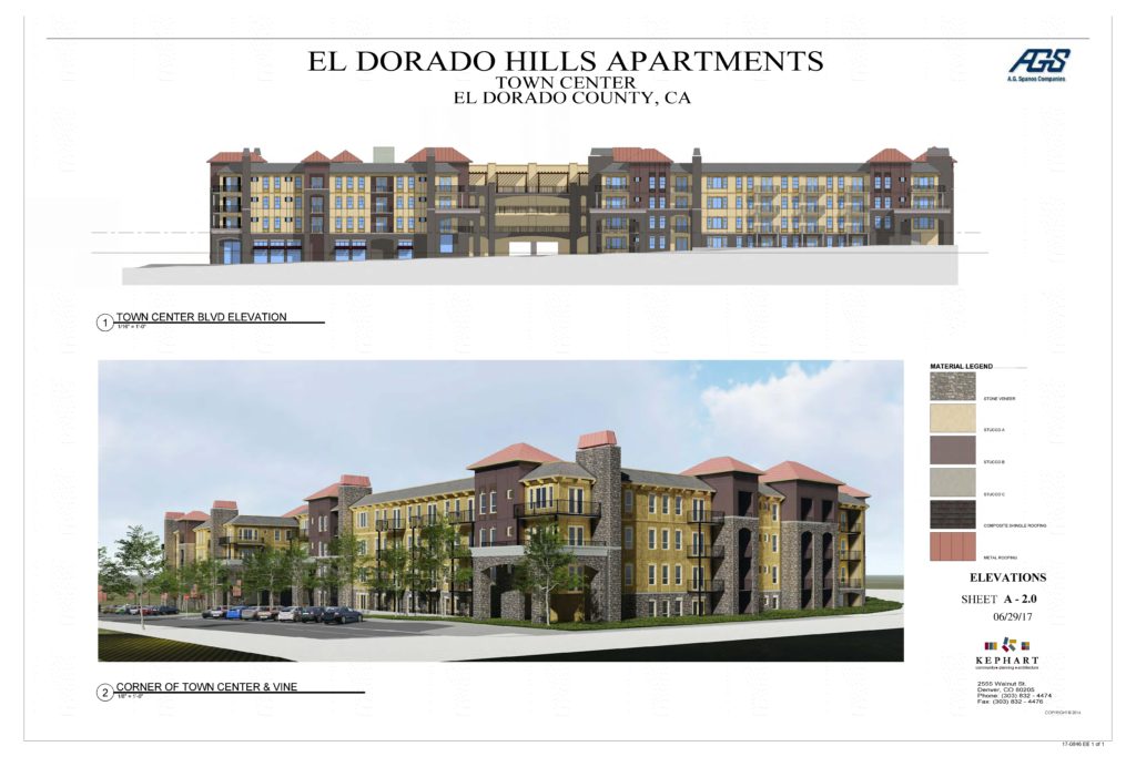
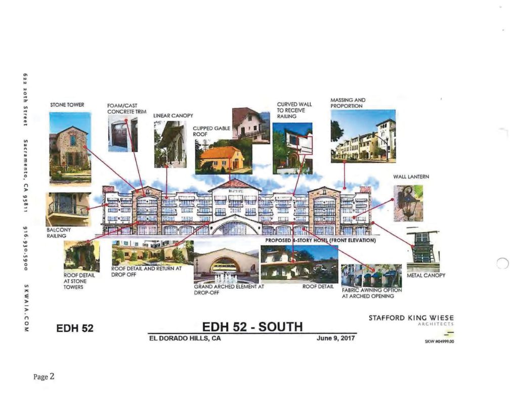
The Project Development Area consists of the northernmost and southernmost 30.3 acres of the project site, and would be developed with two hotels, retail services, two restaurants, a museum, an event center, associated parking, 56 residential cottages for employee housing, and an additional 56 residential cottages that may be rented on a daily or extended stay basis, which may require a conditional use permit.

A second project site of the development is “the Program Study Area” – this site consists of the central and easternmost 30.2 acres of the project site, and may include further development in the future such as additional hotels, medical facilities, senior housing, townhomes and cottages, and other uses allowed by the proposed zoning districts.

The project seeks the following entitlements:

General Plan Amendment

The General Plan Land Use Designation for the project site is Adopted Plan (AP). The General Plan designates the portion of the project site north of Country Club Drive as within the El Dorado Hills Community Region, and the area south of Country Club Drive as within the Rural Region. The proposed General Plan Amendment would modify the Community Region boundary to include the entire project site within the El Dorado Hills Community Region

Bass Lake Hills Specific Plan Amendment

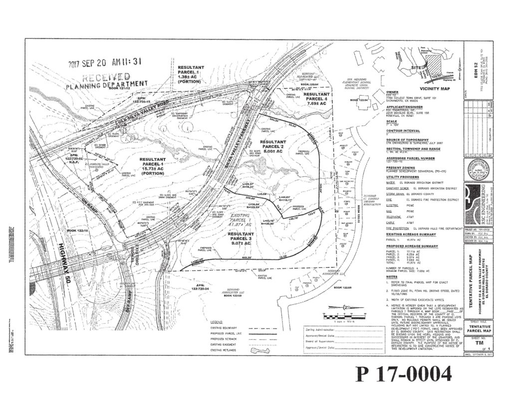
The existing BLHSP land use designations for the project site are L.7-PD and L.2-PD. The BLHSP designates the portion of the project site north of Country Club Drive as L.7-PD [maximum allowable density of 0.7 dwelling units per acre (du/ac)], and the portion south of Country Club Drive is designated L.2-PD (maximum allowable density of 0.2 du/ac). The requested BLHSP Amendment would establish three new land use designations for the specific plan: Commercial (C), Multi-Family Residential (MFR), and Open Space (OS). Application of these proposed new land use designations would be limited the project site. These land use designations would be allocated to the project site as follows: 26.2 acres of C, 23.0 acres of MFR, and 7.6 acres of OS. In addition to changing the land use designations of the project site, the BLHSP Amendment would include content revisions to the BLHSP itself to accommodate the proposed project. As part of the BLHSP Amendment, a Fiscal Impact Analysis and update to the Bass Lake Hills Specific Plan Public Facilities Financing Plan (PFFP) would be completed. The PFFP sets forth a strategy to finance the backbone infrastructure and other public facilities required to serve the proposed land uses in the BLHSP.

Rezone

The current zoning designation for the entire project site is RE-10. The proposed project would require the approval of a Rezone from RE-10 to the following El Dorado County zoning districts: Community Commercial (CC), Multi-Unit Residential (RM), and Open Space (OS). Additionally, as required by the BLHSP, the Planned Development Combining District (-PD) suffix would be added to all the zoning district designations listed above.


Buildout of the Project Development Area of the project site would include two 150-room hotels, 112 residential cottages, retail uses, restaurants, an event center/museum, recreational amenities, and parking lots (see Figure 3).

Additionally, the Project Development Area would be developed with internal roadways and a new Class I Bicycle Path. Development within the Program Study Area of the project site is not currently proposed to occur concurrently with development of the Project Development Area; however, a maximum buildout scenario is included for program level analysis in the EIR.

Two Scoping Meeting dates:

Two scoping meetings – both open to agencies, organizations, and individuals – will be held to receive public comments and suggestions on the scope of environmental issues to be studied in the EIR. The scoping meetings will be held as follows:

In-Person Tue Aug 8, 2023 6PM
An in-person scoping meeting will be held: Date: Tuesday, August 8, 2023 Time: 6:00 PM Location: El Dorado Hills Fire Department Community Room 1050 Wilson Boulevard El Dorado Hills, CA 95762

Virtual Wed Aug 9, 2023 11AM
A virtual scoping meeting will be held: Date: Wednesday, August 9, 2023 Time: 11:00 AM Link: https://us06web.zoom.us/j/86521211649 Call In Phone #’s: 530-621-7603 or 530-621-7610 Webinar ID: 865 2121 1649

EDH APAC encourages residents to attend one or both of the planned Scoping Meetings to provide comments, questions, and concerns. Comments will be addressed as required by law in the California Environmental Quality Act (CEQA) and included in the Final Environmental Impact Report.

Project Documents

Project Documents and links are available on the EDH APAC project Document page:
https://edhapac.org/documents/town-and-country-village-el-dorado-pa21-0013/

Project Frontier Applicant and County Auditor Controller Responses to EDH APAC

Project Applicants provide responses to EDH APAC comment letter submitted for February 16, 2023 TAC Meeting

The applicants for Project Frontier, a proposed distribution and sortation facility consisting of two buildings totaling four million square feet, to be located at the southern end of the El Dorado Hills Business Park on the west side of Latrobe Road between Royal Oaks Drive on the north, and Wetsel-Oviatt Road to the south, have supplied a response letter to the comments submitted by EDH APAC to the El Dorado County Technical Advisory Committee Meeting held on February 13, 2023. The response letter indicates that the project’s application for a Conditional Use Permit (CUP) to allow one of the project’s buildings to exceed current El Dorado County height limits, has been provided a determination by the County Planning Department that the appropriate decision making authority rests with the Zoning Administrator (Director of Building and Planning).

From the response letter:

The project applicant has applied for a conditional use permit to allow one of the buildings to exceed current height limits. A conditional use permit is a discretionary approval and the El Dorado County Zoning Code (“Zoning Code”) requires a noticed public meeting for a conditional use permit. Section 130.52.021 provides for the Zoning Administrator or Planning Commission to be the review authority for a conditional use permit, and “[t]he determination of the review authority shall be made by the Director based on the nature of the application, and the policy issues raised by the project.”

A conditional use permit is not required to allow the project uses. The Matrix of Allowed Uses in Table 130.23.020 of the County Zoning Code provides that “Wholesale Storage and Distribution,” the same use as the proposed project, is an allowed use in the Research and Development Zone. A local agency cannot selectively or arbitrarily require a discretionary approval for uses that the Zoning Code allows by right with a ministerial building permit approval.

The applicant understands that, because the proposed project uses are consistent with zoning, are allowed by right, and have been previously analyzed in numerous environmental analyses, the Planning Department has determined that the Zoning Administrator is the appropriate decision-making body for the conditional use permit that is limited to the proposed building height.

The full response letter addressing the items raised by EDH APAC is embedded here:

March 14, 2023 Applicant Responses to EDH APAC Feb 16, 2023 TAC Meeting Comments Letter

EDC Auditor Controller March 14, 2023 letter to EDH APAC

El Dorado County Auditor Controller Joe Harn provided the following letter to EDH APAC addressing Sales Tax and Apportionment questions raised by EDH APAC.

Auditor Controller Harn’s letter is embedded here:


Project Frontier Applicant Presentation at the EDH APAC March 15, 2023 6:30PM meeting

The project applicants will provide a project presentation and discussion at the Wednesday March 15, 2023 6:30PM EDH APAC Meeting. The meeting will be hybrid: in-person at EDH Fire Station 85 1050 Wilson Blvd, with virtual discussion via ZOOM, and streamed live on the EDH APAC YouTube Channel. The Room capacity does not exceed 100 guests. Meeting details and streaming links can be found on our March 13th meeting event page

EDH APAC Project Documents page updated with Draft Traffic Impact Analysis Report and all available project documents.

To read all public project documents, including the DRAFT Traffic Impact Analysis Report, visit the EDH APAC Project Documents Page for Project Frontier

Notice Of Availability DEIR Montano de El Dorado Phase 2

The County of El Dorado Planning and Building Department, Planning Division, as the Lead Agency, has prepared a Draft Environmental Impact Report (DEIR) for the proposed Montano De El Dorado Phase I and II Master Plan Project.

The Project is comprised of a rezone of a 16.85 property form REGIONAL COMMERCIAL- DESIGN CONTROL (CR-DC) to REGIONAL COMMERCIAL- PLANNED DEVELOPMENT (CR-PD) as part of the Montano de El Dorado Development Plan. The project is located on the east side of Latrobe Road, 500 feet south of the intersection with White Rock Road.

From the County’s Notice Of Availability announcement:

DOCUMENT AVAILABILITY AND REVIEW PERIOD: This DEIR is available for public and agency review for a 45-day period beginning Saturday, May 30, 2020 and ending Monday, July 13, 2020. The purpose of this comment period is to consider the content of the DEIR and the potential environmental impacts that may result from project implementation, not the positive or negative attributes of the Project itself. Comments pertaining to the impact analysis, criteria and thresholds, mitigation measures, and alternatives presented in the DEIR will be considered by the County during preparation of the Final EIR (FEIR).

All written public and agency comments on the DEIR must be received by 5:00 PM on Monday, July 13, 2020 and should be directed to: El Dorado County Planning and Building Department, Planning Division, Attention: Tom Purciel, 2850 Fairlane Court, Placerville, CA 95667. Include the name of the contact person of your agency, if applicable.

Comments may be submitted via email to montano@edcgov.us. Comments submitted via email must either be included in the body text of the message or as an attachment in Microsoft® Word or Adobe® PDF format. Comments may also be submitted via fax to (530) 642-0508.

PUBLIC WORKSHOP: The DEIR is scheduled for a public workshop before the Planning Commission on June 25, 2020. The purpose of this workshop is to present information on the DEIR and receive public input; no action will be taken. To subscribe to Planning Commission agendas and minutes visit: https://www.edcgov.us/Government/planning/Pages/planning_commission.aspx and register your email address with the County’s free email subscription service. When registering, please select “Planning Commission agenda” from the list of topics provided. Planning Commission agendas are posted online no less than 72 hours prior to the meeting at: https:\eldorado.legistar.com/Calendar.aspx.

El Dorado County Notice of Availability: DEIR Montano de El Dorado Phase 2

Loader Loading...
EAD Logo Taking too long?

Reload Reload document
| Open Open in new tab

Download Notice Of Availability [2.40 MB]

Proposed Entitlement Requests:

  • A Rezone (Z15-0002) of the 16.85-acre Phase II property from Regional Commercial- Design Control (CR-DC) to Regional Commercial- Planned Development;
  • A Commercial Tentative Parcel Map (P15-0006) on the 16.85-acre Phase II parcel creating a total of 12 commercial lots, ranging from 0.72 acres to 3.48 acres in size, as part of the proposed Montano De El Dorado Phase 2 Development Plan; and
  • A Planned Development Permit (PD15-0004) for the existing Montano De El Dorado Phase 1 Development and the proposed Phase II expansion. The proposed Phase 2 of the development would include approximately 74,000 square feet of retail/commercial space within eight buildings, 6,000 square feet of office space, 63,000 square feet, 99-room hotel, and an amphitheater.
  • Modifications to an existing Conditional Use Permit (S17-0015) for Phase I to allow outdoor special events and office uses within existing Phase 1 and the proposed Phase II.

EDH APAC Montano de El Dorado Phase 2 Documents Page

DR19-0003 Saratoga Retail Phase 2 Update

On July 5, 2019, a Notice of Decision by the County of El Dorado Planning and Building Department to take action on the proposed revisions to the approved Saratoga Retail Project in El Dorado Hills was issued.

From the Notice of Decision:

A design review application modifying the approved site plan and related exhibits associated with the Saratoga Retail Phase 2 Design Review (DR-R18-0001) approved on October 9, 2018 by the Board of Supervisors. This design review seeks the approval of the Planning Director for proposed minor changes and making a determination of substantial conformance with the approved project referenced above and Conditions of Approval, in accordance with the County of El Dorado Zoning Ordinance Title 130, Article 5, Section 130.54.070 (Revision to an Approved Permit or Authorization).

The DR19-0003 application is being processed in accordance with Title 130, Article 5, Section 130.50.040 (General Review Procedure), as a staff-level review with public notice. The decision to approve this project may be appealed to the Planning Commission by formally filing an appeal along with payment of applicable fees to the County of El Dorado Planning and Building Department within the appeal period. The appeal period is 10 working days starting on Monday, July 8, 2019 and ending at 5:00 pm on Friday, July 19, 2019 (end of business day).

Changes to the 2018 approved project stem from a lawsuit submitted by area residents concerned with the inclusion of a high volume drive thru business. The applicant has engaged with area residents in a discussion to make the project better fit the neighborhood. To this end, changes have been made to Building 3 converting it from a single tenant building, to a multi-tenant building for up to three tenants, eliminating the high volume drive thru facility, and replacing it with a lower volume drive thru tenant: suggested to be a coffee house business tenant.

From the Applicant’s May 9, 2018 Submittal Packet:

This application seeks the approval of the Planning Director that the attached plans and elevations substantially conform to the approved site plan associated with the Saratoga Retail Phase 2 Design Review approved October 9, 2018 by the Board of Supervisors. The attached site plan is a culmination of discussions with neighbors of the project which objected to the approved plan primarily due to the inclusion of a high volume drive through facility. Accordingly, the primary difference between this site plan and the approved site plan is a reconfiguration of Building 3 to make it more amenable to a multi-tenant building and the reduction of the drive through facility to a one lane configuration. Other minor changes are made to the parking and drive aisles as a result of these minor changes, which may be typical of changes that occur from tentative to final site design.

At the time of the approval of the Saratoga Retail project in 2009, the Phase 2 area had an approved site plan which was not dissimilar to the proposed site plan herein. The significance of this is that the site has already be graded and drainage and other infrastructure has already been installed at the site. The proposed site plan comports with the previously constructed improvements thus avoiding any significant changes to the site.

In preliminary discussions with Planning Department staff concerns were raised regarding the possible traffic implications of the requested change to the site plan. Specifically it was pointed out that the drive through as proposed will be conducive to a coffee business which could result in more AM traffic trips thus affecting the conclusions of the other traffic reports prepared for the project. Attached is another traffic report examining the potential impact of the drive through being utilized by a typical retail coffee facility, which concludes no impacts different than those originally identified in previous studies.

This project was approved October 9, 2018, following a denial of an appeal filed by area residents, of the project’s previous approval. The July 5, 2019 Notice of Decision confirms consistency and final approval of the changes requested in the May 9, 2019 Design Review of the previously approved project.

The EDH APAC document page for DR-R18-0002 contains project details and document links.

New Supporting Documents Added to CUP18-0006 El Dorado Disposal Recycling Facility In El Dorado Hills

Nine new supporting documents have been added to the eTRAKiT file for the proposed Conditional Use Permit for El Dorado Disposal to operate a  temporary debris and green waste processing facility.

The property, identified by Assessor’s Parcel Numbers 117-020-08 and 117-020-09, consists of 97 acres, and is located on the end of Wetsel/Oviatt Road  approximately 1.4 miles west of the intersection with Latrobe Road, in the El Dorado Hills area. This will function as a temporary sorting location for the existing Material Recovery Facility (MRF) on Throwita Way in Placeville/Diamond Springs while the existing MRF is reconfigured and soil contamination is corrected over a proposed three year period.

The Throwita Way MRF will continue to be used for serving the public. Materials from the MRF will be transported by El Dorado Disposal vehicles to the Wetsel/Oviatt Road temporary facility for sorting. From there the sorted materials will enter the existing El Dorado Disposal waste streams. There will be no public access at the Wetsel/Oviatt Road temporary facility, and no access from other commercial or municipal waste handlers.

The EDHAPAC CUP18-0006 Project Document(s) Page is HERE
From the October 4, 2018 Proposed Mitigated Negative Declaration and Initial Study_Staff Report Exhibit H (CUP18-0006)
*(Page 33/44) –

Ditches and berms exist on‐site that direct some run‐on stormwater around the site and into an existing stormwater basin. Minor grading and culvert installation would occur to create drainage
swales to route all stormwater run‐on around the facility and stormwater runoff into a proposed stormwater basin. Minor grading would also occur to construct a level pad for the C&D sorting line.
Overall, temporary site construction activity would consist of minor grading to construct a level pad and drainage swales, excavating a stormwater detention basin, construction of a temporary concrete pad, installation of temporary trailer/office, portable toilets, and temporary power, and paving portions of the site. Construction activity is expected to last 20 working days. The temporary site would require approximately 700 cy of soil fill and 3,000 cy of soil cut. The excess soil quantities would be stockpiled on‐site. Construction of the temporary site is expected to take approximately 20 workdays.

Temporary Off‐site Facility—Trip Generation
C&D debris and green/wood waste delivered to the MRF by the public would be transferred to this site. The temporary site would utilize existing access provided by Wetsel‐Oviatt Road. No paving or other improvements to this road are planned. Franchise greenwaste truckloads (route trucks) and separated C&D debris commercial truckloads would be diverted from the MRF and delivered directly to the site. Based on information provided by the Draft Joint Technical Document Containing Facility Plan for C&D Recycling Operations Plan for Green/Wood Waste Processing by Lawrence & Associates (Appendix I), it is anticipated that the temporary site would incur an average of 55 daily two‐way traffic trips. Of these, approximately 49 trips are trips diverted from the existing site to the temporary site. Of these diverted trips, approximately 29 trips would consist of greenwaste and C&D waste truck trips and the remaining 20 trips would consist of employee and visitor trips. The remaining 6 two‐way trips would be new and consist of maintenance and fueling truck trips and water truck trips. The greenwaste and C&D waste truck trips consist of set routes to the MRF facility. As a result of the diversion of the truck trips to the temporary site, some greenwaste and C&D waste truck trip routes would result in a reduction in total vehicle miles traveled (VMT), while other trip routes would result in an increase in total VMT. Based on information provided by the applicant, the net increase of total VMT for the diverted truck trips would result in an additional 1,504 miles per year. The new maintenance and fueling truck trip lengths are based on the Draft Joint Technical Document Containing Facility Plan for C&D Recycling Operations Plan for Green/Wood Waste Processing by Lawrence & Associates (Appendix I). The total trip lengths for employees and visitors are based on the CalEEMod default trip lengths for general industrial projects.

1.5 ‐ Required Discretionary Approvals
The proposed project would require the following discretionary approvals:
 Conditional Use Permit Update (Existing Site)—El Dorado County
 Conditional Use Permit (Temporary Site)—El Dorado County
 Extension of sewer facilities—El Dorado Irrigation District
 Right‐of‐Way Abandonment—El Dorado County Department of Transportation

As previously indicated, the MRF operates under an existing special use permit. Because this project is primarily a renovation of existing operations, the existing special use permit would be revised via an updated Conditional Use Permit. As part of the revision, the total allowable daily tonnage would no longer be split up into waste types, but instead simplified to 700 tpd maximum. This maximum tpd is consistent with the existing permit, but allows for more flexibility in the amount of each waste type received. Actual waste processed at the site is not expected to change as a result of the renovation or update to the Special Use Permit.

DR08-0003-R Saratoga Retail Drive-Thru Modified Project

The project applicants for DR08-0003-R are exploring a revised configuration of their project that was denied by the El Dorado County Planning Commission in February 2018.

The previous project was seeking a design review: adding a third building, but reducing overall square footage of the commercial space. Two buildings were proposed to be fast food drive-thru restaurants, and a third building that would be a non-food retail space.

The revised proposal is to eliminate one of the fast food buildings, and returning to the previously approved two building configuration, again with reduced square footage. One building is proposed to be a fast food drive-thru, the second building will be a non-food retail space. By removing the third building the applicant suggests that they would be able to accommodate RV parking.

The applicant is conducting a public outreach meeting with El Dorado Hills residents on June 26, 2018, at 6:00PM at the Holiday Inn Express in El Dorado Hills Town Center.

Loader Loading...
EAD Logo Taking too long?

Reload Reload document
| Open Open in new tab

Download [2.63 MB]

Planning Commission To Hold Hearings on THREE El Dorado Hills Projects Dec 14 2017

The El Dorado County Planning Commission has scheduled to hold hearings on three significant projects impacting El Dorado Hills, on December 14 2017, starting at 8:30AM in Placerville. The order of the hearings has not been determined. Public Comment NEEDS TO BE RECEIVED no later than December 13 2017.

Event details HERE

El Dorado Hills Apartments at Town Center East APAC FILES HERE
The project applicant is seeking four distinct entitlements:
(1) General Plan Amendment adding a new policy under Objective 2.2.6 (Site Specific Policy Section) increasing the maximum residential density allowed in the General Plan from 24 dwelling units/acre to a maximum of 47 dwelling units/acre for the 4.565-acre site within the Town Center East Planned Development area identified as Assessor’s Parcel Numbers 121-290-60, 121-290-61, and 121-290-62;
(2) El Dorado Hills Specific Plan Amendment incorporating multifamily residential use, density, and related standards for the apartment project. The project site would be designated as “Urban Infill Residential” within the Village T area of the El Dorado Hills Specific Plan;
(3) Rezone of project site from General Commercial-Planned Development (CG-PD) to  multifamily Residential-Planned Development (RM-PD) and revisions to the Multifamily Residential zone district development standards applicable to the proposed 214-unit apartment complex; and
(4) Revisions to the approved Town Center East Development Plan incorporating multifamily residential use, density, and related design and development standards for the proposed 214-unit apartment complex within Planning Area 2 of the Town Center East Development Plan.
The proposed apartment complex would be contained in two 4-story, 60-foot-tall buildings and a 5-level, 60-foot-tall parking garage and other on-site amenities. The property, identified by Assessor’s Parcel Numbers 121-290-60, 121-290-61, and 121-290-62, consisting of 4.56 acres, is located on the northwest corner of Town Center Blvd. and Vine Street, within the Town Center East Planned Commercial Center, in the El Dorado Hills area, Supervisorial District 1. (County Planner: Mel Pabalinas) (Environmental Impact Report prepared, State Clearinghouse No. 201704217)

EDH APAC voted 7-0 non-support for this project in August 2017

Public comments can be submitted on the project by December 13, 2017
Address public comments to :
County Planner Mel Pabalinas [ rommel.pabalinas@edcgov.us ]
Please be certain to cc: planning@edcgov.us
As well as the Clerk of the Planning Commission, Char Tim [ charlene.tim@edcgov.us ]


Saratoga Retail (previously The Shops at El Dorado Hills) APAC FILES HERE
The Planning Commission is considering an application for a Design Review Revision- to add one building and reduce square footage by 6,907 square feet from Design Review DR08-0003/The Shops at El Dorado Hills, that was originally approved by the Planning Commission in 2009 with 3 buildings totaling 30,628 square feet. Phase 1 has been constructed as a Walgreens (13,263 square feet). Phase 2 is proposed to be 3 buildings totaling 10,458 square feet consisting of: one 2,800 square foot restaurant with a drive-thru lane; one 3,000 square foot retail commercial building; and one 4,658 square foot restaurant with a drive-thru lane. The property, identified by Assessor’s Parcel Numbers 120-690-07 and 120-690-08, consisting of 1.71 acres, is located on the west side of El Dorado Hills Boulevard, south of the intersection with Saratoga Way, in the El Dorado Hills area, Supervisorial District 1. (County Planner: Efren Sanchez) (Negative Declaration prepared)*

*This is a notice of intent to adopt the negative declaration or mitigated negative declaration that has been prepared for this project and which may be reviewed and/or obtained in the County of El Dorado Planning and Building Department, 2850 Fairlane Court, Placerville, CA 95667, during normal business hours or online at http://edcapps.edcgov.us/Planning/ProjectInquiry.asp. A negative declaration or mitigated negative declaration is a document filed to satisfy CEQA (California Environmental Quality Act). This document states that there are no significant environmental effects resulting from the project, or that conditions have been proposed which would mitigate or reduce potential negative effects to an insignificant level.

EDH APAC sent this letter to El Dorado County Community Development Agency / Development Services Department, Planning Division on August 31 2017 – no response has been received.

November 9 2017 Proposed Negative Declaration and Initial Study DR08-0003-R (506 pages)

Public comments can be submitted on the project by December 13, 2017
Address public comments to :
County Planner Efren Sanchez [ efren.sanchez@edcgov.us ]
Please be certain to cc: planning@edcgov.us
As well as the Clerk of the Planning Commission, Char Tim [ charlene.tim@edcgov.us ]


El Dorado Hills Memory Care (The Pavilions) APAC FILES HERE
The County of El Dorado Planning Commission will hold a public hearing to consider Planned Development PD16-0003/El Dorado Hills Memory Care (The Pavilions) submitted by FAMILY REAL PROPERTY for a Planned Development permit to allow the construction and operation of a 64-bed, single-story, 38,784 square-foot memory care facility. The project includes a maximum of 42 parking stalls (including 12 reserve stalls), landscaping, and three monument signs. The facility will be accessed from Francisco Drive and Cambria Way. The property, identified by Assessor’s Parcel Number 124-140-33, consisting of 6.85 acres, is located on the southwest corner of Green Valley Road and Francisco Drive, in the El Dorado Hills area, Supervisorial District 1. (County Planner: Mel Pabalinas) (Mitigated Negative Declaration prepared)*
The draft mitigated negative declaration for the PD16-0003 project addresses environmental issues including Aesthetic/Visual, Air Quality, Biological Resources, Drainage/Absorption, Flood Plain/Flooding, Forest Land/Fire Hazard, Geologic/Seismic, Noise, Public Services/Facilities, Traffic/Circulation, Vegetation, Water Quality, Wetland/Riparian, and Land Use. No hazardous waste sites are located within the vicinity of the project. Mitigation has been identified which would reduce potentially significant impacts to a level of insignificance.

*This is a notice of intent to adopt the negative declaration or mitigated negative declaration that has been prepared for this project and which may be reviewed and/or obtained in the County of El Dorado Planning and Building Department, 2850 Fairlane Court, Placerville, CA 95667, during normal business hours or online at http://edcapps.edcgov.us/Planning/ProjectInquiry.asp. A negative declaration or mitigated negative declaration is a document filed to satisfy CEQA (California Environmental Quality Act). This document states that there are no significant environmental effects resulting from the project, or that conditions have been proposed which would mitigate or reduce potential negative effects to an insignificant level. The public review period for the negative declaration or mitigated negative declaration set forth in CEQA for this project is thirty days, beginning November 14, 2017, and ending December 13, 2017.

11/9/2017
Proposed Mitigated Negative Declaration and Initial Study_PD16-0003
11/9/2017
Proposed Mitigated Negative Declaration and Initial Study_Attachments A-O_PD16-0003
11/9/2017
Proposed Mitigated Negative Declaration and Initial Study_Attachments P-S_PD16-0003
11/9/2017
Proposed Mitigated Negative Declaration and Initial Study_Attachment T_PD16-0003

Public comments can be submitted on the project by December 13, 2017
Address public comments to :
County Planner Mel Pabalinas [ rommel.pabalinas@edcgov.us ]
Please be certain to cc: planning@edcgov.us
As well as the Clerk of the Planning Commission, Char Tim [ charlene.tim@edcgov.us ]

Development Application Submitted For EDH 52 At Silva Valley

An application has been submitted to El Dorado County, and posted on the project status page on October 13, 2017  by RSC Engineering Inc on behalf of EDH 52 GP for a commercial center consisting of a total of 290,000 square feet in the Silva Valley Parkway and Tong Road area. The plan provides details for components involving a hotel, restaurant with drive thrus, a grocery store and a self storage facility. The applicants seek three new entitlements to the project, which include a rezone, tentative parcel map, and conditional use permit.

The project description from the application:

The owner is requesting approval to construct two (2) new commercial centers (collectively, the “Project”) in El Dorado County on APN 122-720-15. The property is located north of Highway 50 and Tong Road, east of Old Silva Valley Parkway, and is bisected by Silva Valley Parkway. The northern portion of the property is approximately 17.07 acres (North Site) and the southern portion is approximately 15.73 acres (South Site), net of the right of way for roads. There is a 7.69-acre area on the North Site for the right of way associated with the future extension of Country Club Drive. There is a 1.3 8-acre open space area west of Old Silva Valley Road that will not be developed.

The County is reviewing the owner’s request as a single application and project for local entitlement and California Environmental Quality Act purposes. However, the owner views the North Site and the South Site as two distinct projects, and each constitutes a separate “integrated development” pursuant to El Dorado County Code Section 130.16.120. Accordingly, the owner will seek separate wetlands permits from the Army Corps of Engineers for each. The maximum building area for the South Site will be approximately 110,000 square feet and may include the following uses: hotel, drive through uses, gas station with car wash, grocery, pharmacy, retail, food uses, outdoor patio, medical office, surgery center, office, technical school, outdoor storage and outdoor sales. The maximum building area for the North Site will be approximately 180,000 square feet and may include self-storage, grocery, and other commercial uses.

The Project requires a Planned Development application because the property is zoned PD-CR. A rezone is proposed to PD-CC to allow more uses primarily seen in a shopping center setting and to allow a self-storage use with the approval of a conditional use permit. In addition, a design review permit will be required for signage and a tentative parcel map is proposed to subdivide the parcels further for purposes of sale, lease or financing of the property.

The maximum building area for the South Site will be approximately 110,000 square feet and may include the following uses: hotel, drive through uses, gas station with car wash, grocery,  pharmacy, retail, food uses, outdoor patio, medical office, surgery center, office, technical school, outdoor storage and outdoor sales. The maximum building area for the North Site will be approximately 180,000 square feet and may include self-storage, grocery, and other community serving commercial uses.

Signage

The owner is also requesting certain deviations from Chapter 130.16 of the County Code for the proposed monument signs, including a reduction in the minimum separation between monument signs, an increase in the maximum number of signs allowed per street frontage, an increase in the maximum allowed area, and an increase in the maximum allowed height. The developer is proposing six (6) 28 foot tenant monument signs allowing advertising from either commercial center. Each monument sign will have one (1) featured tenant panel and six (6) shop tenant panels. The proposed area for each monument sign is 242 square feet. The monument signs -3- will have a stone veneer base, fabricated aluminum panels, and texcote finish to compliment the color scheme of the commercial centers. Tenant names and logos will be routed out with acrylic push-through graphics and vinyl film overlays. Tenant names will be internally illuminated with white LED lights. Colors will comply with tenant specifications.
Building signs will be a part of a separate sign permit and are not proposed at this time.

Site Access

It is anticipated that the Project site will have multiple points of access. A traffic signal is proposed at the main driveway and Silva Valley Parkway to provide access to both the South Site and the North Site. A right in and right out access driveway is proposed on Silva Valley Parkway north of the signalized driveway and at the old Tong Road location to provide access to the North Site. Two full access driveways are proposed on Old Silva Valley Road to provide additional points of access to the South Site.

On Site Improvements

The Project is designed to allow either the North Site or the South Site to develop independent from the other. Mass grading of each site to accommodate future development will occur in the first phase of development, including filling of the permitted wetlands and permitted tree removal. In the event the South Site develops first, utility crossings under Silva Valley Parkway will be  constructed as part of the South Site infrastructure work to serve the North Site. In the event the North Site develops first, interim facilities will be constructed on the North Site.

The second phase will include construction of the parking, landscaping, lighting, utility infrastructure, and driveways designed to support the buildings. Site improvements will be constructed in various phases depending on the extent of development occurring at any given time. Buildings can be started once site improvements are sufficiently completed to allow construction and emergency fire access.

Off Site Improvements

A proposed traffic signal and appurtenant facilities will be located on Silva Valley
Parkway at the center of the Project to provide a connection to both the South Site and the North
Site.
A right in and right out access driveway is proposed on Silva Valley Parkway north of the signalized driveway and at the old Tong Road location to provide access to the North Site. Two full access driveways are proposed on Old Silva Valley Road to provide additional points of access to the South Site. A reservation for 7 .65 acres of future right of way is proposed along the outer boundary of the North Site.

The project seeks to be annexed into the El Dorado Irrigation District for water and sewer service.

The APAC  document page for the project can be found HERE

Some of the application design images and maps:


EDH 52 Development At Silva Valley HWY50 Tentative Parcel Map Filed Sep 20 2017

Application Packet P17-0004 was filed on September 20 2017 by RSC Engineering, Inc. of Roseville on behalf of property owner EDH 52 GP of Sacramento for a Parcel split of property located along Silva Valley Pkwy near Highway 50 and Tong Rd. in El Dorado Hills. The Application status can be viewed online. The single parcel was bisected by the re-aligned Silva Valley Pkwy interchange. The applicants seek to split the property into four parcels. The northern parcel will be subdivided into 3 parcels, one for the future Country Club Dr. extension and 2 additional parcels for finance purposes.

A Planned Development was filed in 2015 (PD15-0001) for EDH 52 Retail Shopping Center on 48 acres along Silva Valley Pkwy near Tong Rd. The current application status indicates:

PLANNED DEVELOPMENT FOR A NEW RETAIL CENTER AT 122-720-09 ON 48.14 ACRES THAT WILL BE BISCECTED BY THE FUTURE SILVA VALLEY PKWY INTERCHANGE AND ROAD REALIGNMENT. NORTH SIDE WOULD BE 24.77 ACRES AND SOUTH SIDE WOULD BE 16.21 ACRES. MAXIMUM BLDG AREA WOULD BE APPROX 350,000 SQ FT AND COULD INCLUDE HOTEL, DRIVE THRU, GAS STATION, GROCERY, PHARMACY, RETAIL AND FOOD USES. PD IS TO BE APPROVED BY THIS APPLICANT AND LIKELY SOLD TO SOMEONE ELSE TO DEVELOP. PROJECT WILL REQUIRE AN EIR.  

The APAC Document section for EDH 52 can be found HERE.

Additional area detail from the application:


Design Review Approval Notice of Decision DR17-0003 El Dorado Hills Ambulatory Surgery Center

NOTICE OF DECISION
County of El Dorado Planning Services has approved the following project: Design Review DR17-0003/El Dorado Hills Ambulatory Surgery Center submitted by RCP CONSTRUCTION (Agent: Rick Poipao) a Design Review application request for the construction of an approximate 22,272 square foot sized building for a new single story ambulatory surgery center. The proposed facility will focus on providing outpatient orthopedic surgical care beyond the medical environment found in a physician’s office. The ambulatory surgery center will operate Monday through Friday during the hours of 8am to 5pm. The project includes an 85 stall parking lot, associated site improvements, and connections to existing utility systems. The property, identified by Assessor’s Parcel Number 120-690-04, is zoned Community Commercial-Design Review Community (CC-DC), consists of 2.11 acres, and is located on the north side of Saratoga Way, approximately 14 feet west of the intersection with Arrowhead Drive, in the El Dorado Hills area, Supervisorial District 1 (County Planner: Efren Sanchez) (Statutory Exempt pursuant to Section 15268 of the CEQA guidelines and Section 130.52.030.B of the Zoning Ordinance.)*

County Link

APAC Project Document page