Skip to content Skip to main navigation Skip to footer

Montano de El Dorado

Montano de El Dorado Phase 2 Public Hearing March 25th

The County of El Dorado Planning Commission will hold a public hearing on March 25, 2021 at 8:30AM to consider:

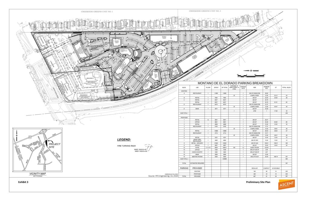
Rezone Z15-0002/Tentative Parcel Map P15-0006/Planned Development PD15-0004/ Conditional Use Permit S17-0015/Montano De El Dorado Phase I and II Master Plan submitted by MONTANO VENTURE 2, LLC to: 1) Rezone (Z15-0002) from Regional Commercial – Community Design Review Combining Zone (CR-DC) to Regional Commercial – Planned Development Combining Zone (CR-PD); 2) Commercial Tentative Parcel Map (P15-0006) on Assessor’s Parcel No. 118-010-012 to create a total of 12 commercial parcels from an existing 16.85-acre parcel, ranging from 0.72 acres to 3.48 acres in size, as part of proposed Phase II of the Montano De El Dorado Master Plan; 3) Planned Development (PD15-0004) to establish a Development Plan for the existing Montano De El Dorado Phase 1 development and the proposed Phase II expansion. Phase I consists of an existing commercial center, consisting of five buildings, on the 20.1-acre project site with a combined total of 39,645 square feet of floor area.  Existing uses include retail stores, restaurants, and a bank. The proposed Phase II expansion consists of nine additional commercial buildings with a combined total of approximately 80,000 square feet of retail, restaurant, commercial and office uses, a 55,136 square foot, 100-room hotel, a small community pavilion and on-site parking, lighting, signage and landscaping; and 4) Conditional Use Permit (S17-0015) to allow outdoor special events and office uses within existing Phase I and proposed Phase II of the Montano De El Dorado Master Plan. The properties, identified by Assessor’s Parcel Numbers 118-010-012, 118-010-014, 118-010-015, and 118-010-016, consisting of 20.1 acres, is located approximately 0.5 mile south of U.S. Highway 50 on the east side of Latrobe Road at the intersection with White Rock Road, in the El Dorado Hills area, Supervisorial District 2. (County Planner: Tom Purciel, 530-621-5903)  [An Environmental Impact Report (EIR) (State Clearinghouse No. 2017072027) consisting of a Draft EIR and Final EIR has been prepared for the project]

County Staff Reports and the project Final Environmental Impact Report (FEIR) as referenced in the Public Notice, have not yet been made available on the County’s Legistar website, or on the County’s eTRAKiT website. Project Documents are typically available about two weeks prior to a public hearing.

Any written correspondence should be directed to the County of El Dorado Planning and Building Department, 2850 Fairlane Court, Placerville, CA 95667 or via e-mail: planning@edcgov.us.

To ensure delivery to the Commission prior to the hearing, written information from the public is encouraged to be submitted by Thursday the week prior to the meeting. Planning Services cannot guarantee that any FAX or mail received the day of the Commission meeting will be delivered to the Commission prior to any action.

The EDH APAC Project Documents Page is HERE

Loader Loading...
EAD Logo Taking too long?

Reload Reload document
| Open Open in new tab

Download NOTICE [136.83 KB]


Notice Of Availability DEIR Montano de El Dorado Phase 2

The County of El Dorado Planning and Building Department, Planning Division, as the Lead Agency, has prepared a Draft Environmental Impact Report (DEIR) for the proposed Montano De El Dorado Phase I and II Master Plan Project.

The Project is comprised of a rezone of a 16.85 property form REGIONAL COMMERCIAL- DESIGN CONTROL (CR-DC) to REGIONAL COMMERCIAL- PLANNED DEVELOPMENT (CR-PD) as part of the Montano de El Dorado Development Plan. The project is located on the east side of Latrobe Road, 500 feet south of the intersection with White Rock Road.

From the County’s Notice Of Availability announcement:

DOCUMENT AVAILABILITY AND REVIEW PERIOD: This DEIR is available for public and agency review for a 45-day period beginning Saturday, May 30, 2020 and ending Monday, July 13, 2020. The purpose of this comment period is to consider the content of the DEIR and the potential environmental impacts that may result from project implementation, not the positive or negative attributes of the Project itself. Comments pertaining to the impact analysis, criteria and thresholds, mitigation measures, and alternatives presented in the DEIR will be considered by the County during preparation of the Final EIR (FEIR).

All written public and agency comments on the DEIR must be received by 5:00 PM on Monday, July 13, 2020 and should be directed to: El Dorado County Planning and Building Department, Planning Division, Attention: Tom Purciel, 2850 Fairlane Court, Placerville, CA 95667. Include the name of the contact person of your agency, if applicable.

Comments may be submitted via email to montano@edcgov.us. Comments submitted via email must either be included in the body text of the message or as an attachment in Microsoft® Word or Adobe® PDF format. Comments may also be submitted via fax to (530) 642-0508.

PUBLIC WORKSHOP: The DEIR is scheduled for a public workshop before the Planning Commission on June 25, 2020. The purpose of this workshop is to present information on the DEIR and receive public input; no action will be taken. To subscribe to Planning Commission agendas and minutes visit: https://www.edcgov.us/Government/planning/Pages/planning_commission.aspx and register your email address with the County’s free email subscription service. When registering, please select “Planning Commission agenda” from the list of topics provided. Planning Commission agendas are posted online no less than 72 hours prior to the meeting at: https:\eldorado.legistar.com/Calendar.aspx.

El Dorado County Notice of Availability: DEIR Montano de El Dorado Phase 2

Loader Loading...
EAD Logo Taking too long?

Reload Reload document
| Open Open in new tab

Download Notice Of Availability [2.40 MB]

Proposed Entitlement Requests:

  • A Rezone (Z15-0002) of the 16.85-acre Phase II property from Regional Commercial- Design Control (CR-DC) to Regional Commercial- Planned Development;
  • A Commercial Tentative Parcel Map (P15-0006) on the 16.85-acre Phase II parcel creating a total of 12 commercial lots, ranging from 0.72 acres to 3.48 acres in size, as part of the proposed Montano De El Dorado Phase 2 Development Plan; and
  • A Planned Development Permit (PD15-0004) for the existing Montano De El Dorado Phase 1 Development and the proposed Phase II expansion. The proposed Phase 2 of the development would include approximately 74,000 square feet of retail/commercial space within eight buildings, 6,000 square feet of office space, 63,000 square feet, 99-room hotel, and an amphitheater.
  • Modifications to an existing Conditional Use Permit (S17-0015) for Phase I to allow outdoor special events and office uses within existing Phase 1 and the proposed Phase II.

EDH APAC Montano de El Dorado Phase 2 Documents Page