
Montano De El Dorado Phase II
REZONE OF 16.85-ACRE PROPERTY FROM REGIONAL COMMERCIAL- DESIGN CONTROL (CR-DC) TO REGIONAL COMMERCIAL- PLANNED DEVELOPMENT (CR-PD) AS PART OF THE PROPOSED MONTANO DE EL DORADO DEVELOPMENT PLAN.
EAST SIDE OF LATROBE ROAD 500 FEET SOUTH OF THE INTERSECTION WITH WHITE ROCK ROAD.
1010 White Rock Road
eTRAKiT pages:
https://edc-trk.aspgov.com/etrakit/Search/project.aspx?activityNo=20500
https://edc-trk.aspgov.com/etrakit/Search/project.aspx?activityNo=20501
https://edc-trk.aspgov.com/etrakit/Search/project.aspx?activityNo=20502
Final Environmental Impact Report
 Loading...
Staff Report
Loading...Findings
Loading...Conditions of Approval
Loading...Draft Environmental Impact Report:
Loading...DEIR Appendix A – C
Montano de El Dorado DEIR Appendix A-C: DUE TO LARGE FILE SIZE, OPEN IN A NEW TAB
DEIR Appendix D
Montano de El Dorado DEIR Appendix D: DUE TO LARGE FILE SIZE, OPEN IN A NEW TAB
DEIR on the El Dorado County Website:
- Montano De El Dorado Phase I and II Master Plan Project (Z15-0002/PD15-0004/P15-0006/S17-0015) – Notice of Availability of a Draft Environmental Impact Report (DEIR) and Notice of Public Workshop
- Montano De El Dorado Phase I and II Master Plan – DEIR
- Montano De El Dorado Phase I and II Master Plan – DEIR Appendices A-C
- Montano De El Dorado Phase I and II Master Plan – DEIR Appendices D-F
Application Status Page (Broken Link to old County Project Status Page)
Planning Commission March 25, 2021 Hearing
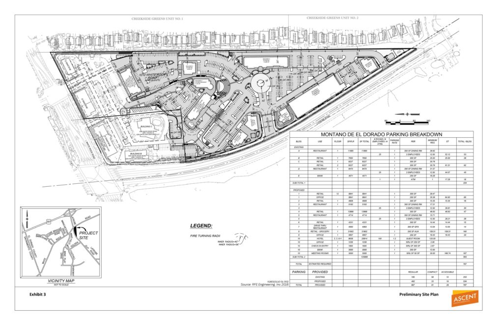
Hearing to consider the Montano De El Dorado Phase I and II Master Plan project (Rezone Z15-0002/Tentative Parcel Map P15-0006/Planned Development PD15-0004/Conditional Use Permit S17-0015) to request: 1) Rezone (Z15-0002) from Regional Commercial – Community Design Review Combining Zone (CR-DC) to Regional Commercial – Planned Development Combining Zone (CR-PD); 2) Commercial Tentative Parcel Map (P15-0006) on Assessor’s Parcel No. 118-010-012 to create a total of 12 commercial parcels from an existing 16.85-acre parcel, ranging from 0.72 acres to 3.48 acres in size, as part of proposed Phase II of the Montano De El Dorado Master Plan; 3) Planned Development (PD15-0004) to establish a Development Plan for the existing Montano De El Dorado Phase 1 development and the proposed Phase II expansion. Phase I consists of an existing commercial center, consisting of five buildings, on the 20.1-acre project site with a combined total of 39,645 square feet of floor area. Existing uses include retail stores, restaurants, and a bank. The proposed Phase II expansion consists of nine additional commercial buildings with a combined total of approximately 80,000 square feet of retail, restaurant, commercial and office uses, a 55,136 square foot, 100-room hotel, a small community pavilion and on-site parking, lighting, signage and landscaping; and 4) Conditional Use Permit (S17-0015) to allow outdoor special events and office uses within existing Phase I and proposed Phase II of the Montano De El Dorado Master Plan on property identified by Assessor’s Parcel Numbers 118-010-012, 118-010-014, 118-010-015, and 118-010-016, consisting of 20.1 acres, in the El Dorado Hills area, submitted by Montano Venture 2, LLC; and staff recommending the Planning Commission forward the following recommendation to the Board of Supervisors:
1) Adopt Resolution XX-2021 (Exhibit G) to certify the EIR (SCH No. 2017072027) for the Montano De El Dorado Phase I and II Master Plan Project (project), subject to California Environmental Quality Act (CEQA) Findings and adopt the Project Mitigation Monitoring and Reporting Program (MMRP) and Statement of Overriding Considerations in compliance with CEQA Guidelines Sections 15091, 15092 and 15093;
2) Adopt a Resolution to rezone the project parcels from Regional Commercial – Community Design Review Combining Zone (CR-DC) to Regional Commercial – Planned Development Combining Zone (CR-PD);
3) Approve Rezone Z15-0002 based on the Findings as presented;
4) Approve Planned Development PD15-0004 as the official Development Plan for the Montano De El Dorado Phase I and II Master Plan project based on the Findings and subject to the Conditions of Approval as presented;
5) Approve Tentative Parcel Map P15-0006 based on the Findings and subject to the Conditions of Approval as presented;
6) Approve Conditional Use Permit S17-0015 to allow outdoor special events and office uses within Phase I and Phase II of the Montano De El Dorado Master Plan based on the Findings and subject to the Conditions of Approval as presented.
(Supervisorial District 2)
Body
DISCUSSION / BACKGROUND
Request to consider Rezone Z15-0002/Tentative Parcel Map P15-0006/Planned Development PD15-0004/ Conditional Use Permit S17-0015/Montano De El Dorado Phase I and II Master Plan submitted by MONTANO VENTURE 2, LLC to: 1) Rezone (Z15-0002) from Regional Commercial – Community Design Review Combining Zone (CR-DC) to Regional Commercial – Planned Development Combining Zone (CR-PD); 2) Commercial Tentative Parcel Map (P15-0006) on Assessor’s Parcel No. 118-010-012 to create a total of 12 commercial parcels from an existing 16.85-acre parcel, ranging from 0.72 acres to 3.48 acres in size, as part of proposed Phase II of the Montano De El Dorado Master Plan; 3) Planned Development (PD15-0004) to establish a Development Plan for the existing Montano De El Dorado Phase 1 development and the proposed Phase II expansion. Phase I consists of an existing commercial center, consisting of five buildings, on the 20.1-acre project site with a combined total of 39,645 square feet of floor area. Existing uses include retail stores, restaurants, and a bank. The proposed Phase II expansion consists of nine additional commercial buildings with a combined total of approximately 80,000 square feet of retail, restaurant, commercial and office uses, a 55,136 square foot, 100-room hotel, a small community pavilion and on-site parking, lighting, signage and landscaping; and 4) Conditional Use Permit (S17-0015) to allow outdoor special events and office uses within existing Phase I and proposed Phase II of the Montano De El Dorado Master Plan. The properties, identified by Assessor’s Parcel Numbers 118-010-012, 118-010-014, 118-010-015, and 118-010-016, consisting of 20.1 acres, is located approximately 0.5 mile south of U.S. Highway 50 on the east side of Latrobe Road at the intersection with White Rock Road, in the El Dorado Hills area, Supervisorial District 2. (County Planner: Tom Purciel) [An Environmental Impact Report (EIR) (State Clearinghouse No. 2017072027) consisting of a Draft EIR and Final EIR has been prepared for the project]
CONTACT
Tom Purciel Planning and Building Department, Planning Division
| Planning Commission March 25, 2021 HEARING DOCUMENTS LEGISTAR 1. A – Staff Report, 2. B – Findings, 3. C – Conditions of Approval, 4. D – Staff Report Exhibits A-F, 5. E – Staff Report Exhibits G-L, 6. F – Staff Report Exhibit M, 7. G – Staff Report Exhibits N-P, 8. H – Staff Report Exhibits Q-V, 9. I – Staff Report Exhibits W-X, 10. J – Staff Report Exhibit Y (DEIR), 11. K – Staff Report Exhibit Z (FEIR), 12. L – Staff Report Exhibit AA, 13. M – Notification Map (1 Mile), 14. N – Proof of Physical Sign Posting (Posted 02-22-21), 15. O – Staff Presentation |
NOTICE OF PUBLIC HEARING: MARCH 25, 2021
The County of El Dorado Planning Commission will hold a public hearing in the Planning Commission Hearing Room, 2850 Fairlane Court, Placerville, CA 95667 on March 25, 2021, at 8:30 a.m., to consider: Rezone Z15-0002/Tentative Parcel Map P15-0006/Planned Development PD15-0004/ Conditional Use Permit S17-0015/Montano De El Dorado Phase I and II Master Plan submitted by MONTANO VENTURE 2, LLC to: 1) Rezone (Z15-0002) from Regional Commercial – Community Design Review Combining Zone (CR-DC) to Regional Commercial – Planned Development Combining Zone (CR-PD); 2) Commercial Tentative Parcel Map (P15-0006) on Assessor’s Parcel No. 118-010-012 to create a total of 12 commercial parcels from an existing 16.85-acre parcel, ranging from 0.72 acres to 3.48 acres in size, as part of proposed Phase II of the Montano De El Dorado Master Plan; 3) Planned Development (PD15-0004) to establish a Development Plan for the existing Montano De El Dorado Phase 1 development and the proposed Phase II expansion. Phase I consists of an existing commercial center, consisting of five buildings, on the 20.1-acre project site with a combined total of 39,645 square feet of floor area. Existing uses include retail stores, restaurants, and a bank. The proposed Phase II expansion consists of nine additional commercial buildings with a combined total of approximately 80,000 square feet of retail, restaurant, commercial and office uses, a 55,136 square foot, 100-room hotel, a small community pavilion and on-site parking, lighting, signage and landscaping; and 4) Conditional Use Permit (S17-0015) to allow outdoor special events and office uses within existing Phase I and proposed Phase II of the Montano De El Dorado Master Plan. The properties, identified by Assessor’s Parcel Numbers 118-010-012, 118-010-014, 118-010-015, and 118-010-016, consisting of 20.1 acres, is located approximately 0.5 mile south of U.S. Highway 50 on the east side of Latrobe Road at the intersection with White Rock Road, in the El Dorado Hills area, Supervisorial District 2. (County Planner: Tom Purciel, 530-621-5903) [An Environmental Impact Report (EIR) (State Clearinghouse No. 2017072027) consisting of a Draft EIR and Final EIR has been prepared for the project]
Loading...Notice of Availability and Notice of Public Workshop-Draft Environmental Impact Report and Hearing Date
Loading...
| 20-0786 Version: 1 |
| Type: | Agenda Item | Status: | Agenda Item |
| File created: | 6/9/2020 | In control: | Planning Commission |
| On agenda: | 6/25/2020 | Final action: |
| Title: | NOTICED WORKSHOP: Planning and Building Department, Planning Division, providing a public workshop on the Montano De El Dorado Master Plan project (Rezone Z15-0002/Planned Development PD15-0004/Tentative Parcel Map P15-0006/Conditional Use Permit S17-0015) to present information on the Draft Environmental Impact Report which is undergoing a 45-day public review from May 30, 2020 to July 13, 2020 and to receive public input. No action by the Planning Commission will be taken. (Supervisorial District 2) |
Loading...Notice of Preparation of a Draft Environmental Impact Report and Notice of Public Scoping Meeting for the Montano De El Dorado Phase II Master Plan
EDH APAC July 9, 2020 DEIR Findings
Loading...EDH APAC March 22, 2021 Planning Commission Hearing Letter
Loading...OCTOBER 1, 2018: Re-Circulation of Notice of Preparation of a Draft Environmental Impact Report for the Montano De El Dorado Phase I and II Master Plan
This re-circulated Notice of Preparation (NOP) has been issued October 1, 2018 due to changes in the project since release of the previous NOP in 2017 and to solicit comments from responsible and trustee agencies and other interested parties regarding the scope and content of the environmental information and analyses that should be included in the Draft EIR.
Loading...| Description: | Z15-0002 Montano De El Dorado Phase I and Phase II Master Pl |
| Type: | ZONE CHANGE |
| Subtype: | |
| Planner: | ROMMEL PABALINAS |
| Status: | PROCESSING |
| Applied: | 7/30/2015 |
| Approved: | |
| Closed: | |
| Expired: | |
| Complete: | |
| Incomplete: | |
Project #PROJ24-0003
Description:
Extensions for Montano PD/P/S
Type:
PROJECT
Subtype:
Planner:
Status:
SUBMITTED
Applied:
6/14/2024
Approved:
Closed:
Expired:
Complete:
10/16/2024
Incomplete:
Linked Activities:Project(s)
| PD-E24-0001 | DEVELOPMENT PLAN EXTENSION | PROCESSING |
| P-E24-0003 | PARCEL MAP-EXTENSION | PROCESSING |
| CUP-E24-0001 | CONDITIONAL USE PERMIT EXTENSION | PROCESSING |